Géolocaliser

Carte topographique Quilotoa

Carte interactive

Cliquez sur la carte pour afficher l’altitude.

À propos de cette carte

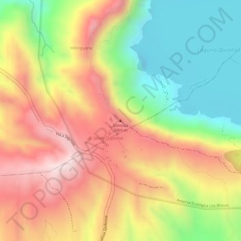
Nom : Carte topographique Quilotoa, altitude, relief.

Lieu : Quilotoa, Chugchillan, Sigchos, Cotopaxi, 050456, Ecuador (-0.84920 -78.89713 -0.84910 -78.89703)

Altitude moyenne : 3 553 m

Altitude minimum : 3 326 m

Altitude maximum : 3 827 m

Quilotoa is a cat site of growing popularity. The route to the "summit" (the small town of Quilotoa) is generally traveled by hired truck or bus from the town of Zumbahua 17 kilometres (11 mi) to the South, or more commonly by bus from Latacunga. Visitors have to pay two US dollars each to enter Quilotoa. There are a number of simple hostels in the immediate area offering services such as mules and guides. Activities include a four to five-hour hike around the caldera (whose diameter is just over 3 kilometres (2 mi)). The caldera rim is highly irregular and reaches its maximum elevations (3,810 metres (12,500 ft) to the N, (3,894 metres (12,776 ft) to the NW and (3,915 metres (12,844 ft) to the SE) at three lava domes. The (10-kilometre (6 mi) hike is sandy and steep in places and can be quite taxing, particularly if there is fog.

Wikipedia (CC-BY-SA 3.0)