Carte topographique Oberhof
Carte interactive
Cliquez sur la carte pour afficher l’altitude.
À propos de cette carte
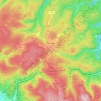
Oberhof is located in the Thuringian Forest, a low mountain range, at an altitude of about 815 meters. The town is located on a plateau, which is why there are no great differences in altitude in the built-up area. About four kilometers to the southeast are the two highest mountains in Thuringia, the 983-meter-high Großer Beerberg and the 978-meter-high Schneekopf. Southwest of Oberhof there are also two Rennsteig passes: the pass at the Grenzadler (former state border between the Duchy of Saxe-Coburg and Gotha and Prussia) and the pass at the Rondell monument. Several rivers also rise near Oberhof, the Gera in the east, the Ohra in the north, the Hasel in the south and the Schönau in the west. The surroundings of Oberhof are completely forested, the most common tree species is spruce.
Autres cartes topographiques
Cliquez sur une carte pour visualiser sa topographie, son altitude et son relief.
Petrus (12. Apostel)
Germany > Thuringia > Landkreis Schmalkalden-Meiningen > Steinbach-Hallenberg
Petrus (12. Apostel), Steinbach-Hallenberg, Landkreis Schmalkalden-Meiningen, Thuringia, Germany
Altitude moyenne : 704 m
Kaltensundheim
Germany > Thuringia > Landkreis Schmalkalden-Meiningen > Kaltennordheim
Kaltensundheim, Kaltennordheim, Hohe Rhön, Landkreis Schmalkalden-Meiningen, Thuringia, 36542, Germany
Altitude moyenne : 513 m
Kerbe
Germany > Thuringia > Landkreis Schmalkalden-Meiningen > Steinbach-Hallenberg > Viernau
Kerbe, Viernau, Steinbach-Hallenberg, Landkreis Schmalkalden-Meiningen, Thuringia, 98587, Germany
Altitude moyenne : 447 m
Einhausen
Germany > Thuringia > Landkreis Schmalkalden-Meiningen
Einhausen, Dolmar-Salzbrücke, Landkreis Schmalkalden-Meiningen, Thuringia, Germany
Altitude moyenne : 379 m