Géolocaliser

Carte topographique Khan Shaykhun

Carte interactive

Cliquez sur la carte pour afficher l’altitude.

À propos de cette carte
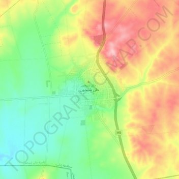
Nom : Carte topographique Khan Shaykhun, altitude, relief.

Lieu : Khan Shaykhun, Khan Shaykhun Subdistrict, Maarat Al-Nu'man District, Idlib Governorate, Syria (35.40007 36.60711 35.48007 36.68711)

Altitude moyenne : 385 m

Altitude minimum : 311 m

Altitude maximum : 480 m

Khan Shaykhun is located at an altitude of 350 meters on the main highway between Aleppo and Damascus. The local economy is primarily agricultural, focusing on the growing of cotton and cereals. The town was formerly known for producing embroidery. Nearby localities include Hbit to the west, Kafr Zita to southwest, Murak to the south and Al-Tamanah to the east. In 2004, it was recorded as having 34,371 inhabitants.

Wikipedia (CC-BY-SA 3.0)

Autres cartes topographiques

Cliquez sur une carte pour visualiser sa topographie, son altitude et son relief.

Idlib District

Syria > Idlib Governorate

Idlib District, Idlib Governorate, Syria

Altitude moyenne : 392 m

Jisr ash-Shugur

Syria > Idlib Governorate > Jisr ash-Shugur

Jisr ash-Shugur, Jish Al-Shughur Subdistrict, Jish Al-Shughur District, Idlib Governorate, Syria

Altitude moyenne : 444 m

Salhab

Syria > Idlib Governorate

Salhab, Darkush Subdistrict, Jisr Al-Shughur District, Idlib Governorate, Syria

Altitude moyenne : 421 m