
Carte topographique Murree
Carte interactive
Cliquez sur la carte pour afficher l’altitude.
Murree
La ville est construite à une altitude de 2 300 mètres. Elle est accessible par la route depuis Rawalpindi et Islamabad. La ville a beaucoup grandi depuis 1947, à un rythme trop élevé pour que les infrastructures puissent suivre. Fournir l'eau courante et l'électricité est un défi permanent pour la ville.
À propos de cette carte
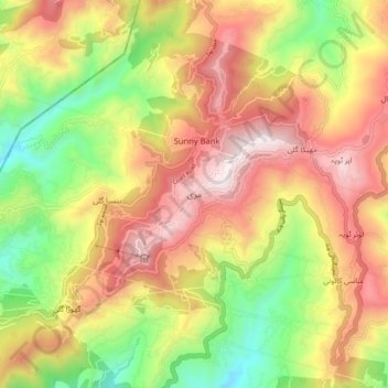
Nom : Carte topographique Murree, altitude, relief.
Lieu : Murree, تحصیل مری, Pendjab, Pakistan (33.86568 73.35267 33.94568 73.43267)
Altitude moyenne : 1 718 m
Altitude minimum : 1 162 m
Altitude maximum : 2 256 m