
Faire un don
Équipez-vous pour votre prochaine aventure :
En tant que Partenaire Amazon, ce site perçoit une commission sur les achats éligibles sans surcoût pour vous.
Carte topographique Bușteni
Cliquez sur la carte pour afficher l’altitude.
Faire un don
Équipez-vous pour votre prochaine aventure :
En tant que Partenaire Amazon, ce site perçoit une commission sur les achats éligibles sans surcoût pour vous.
Bușteni
La ville a été le théâtre de nombreux combats en 1916 entre l'armée roumaine et l'armée austro-hongroise. Après la Première Guerre mondiale, une grande croix métallique (Crucea Eroilor Neamului) de 25 m de haut a été construite à 2 291 m d'altitude, près du sommet du Mont Caraiman, qui domine la ville, en hommage aux nombreux soldats roumains tombés dans les parages.
Faire un don
Équipez-vous pour votre prochaine aventure :
En tant que Partenaire Amazon, ce site perçoit une commission sur les achats éligibles sans surcoût pour vous.
À propos de cette carte
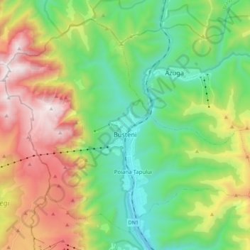
Nom : Carte topographique Bușteni, altitude, relief.
Lieu : Bușteni, Prahova, Roumanie (45.36783 25.45256 45.47040 25.62365)
Altitude moyenne : 1 419 m
Altitude minimum : 807 m
Altitude maximum : 2 500 m
Faire un don
Équipez-vous pour votre prochaine aventure :
En tant que Partenaire Amazon, ce site perçoit une commission sur les achats éligibles sans surcoût pour vous.
Autres cartes topographiques
Cliquez sur une carte pour visualiser sa topographie, son altitude et son relief.