Géolocaliser

Carte topographique Aberystwyth

Carte interactive

Cliquez sur la carte pour afficher l’altitude.

À propos de cette carte

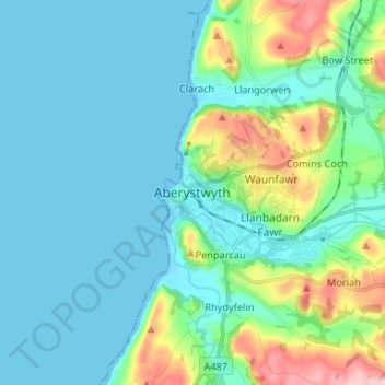
Nom : Carte topographique Aberystwyth, altitude, relief.

Lieu : Aberystwyth, Ceredigion, Wales, SY23 1LH, United Kingdom (52.37431 -4.12168 52.45431 -4.04168)

Altitude moyenne : 39 m

Altitude minimum : -1 m

Altitude maximum : 195 m

Aberystwyth experiences an oceanic climate (Köppen climate classification Cfb) similar to almost all of the United Kingdom. This is particularly pronounced due to its west coast location facing the Irish Sea. Air undergoes little land moderation and so temperatures closely reflect the sea temperature when winds are coming from the predominant onshore (westerly) direction. The nearest Met Office weather station is Gogerddan, 3 miles to the northeast, and at a similar elevation.

Wikipedia (CC-BY-SA 3.0)

Autres cartes topographiques

Cliquez sur une carte pour visualiser sa topographie, son altitude et son relief.

Aberporth

United Kingdom > Wales > Ceredigion

Aberporth, Ceredigion, Wales, SA43 2DB, United Kingdom

Altitude moyenne : 62 m

Cardigan

United Kingdom > Wales > Ceredigion > Cardigan

Cardigan, Ceredigion, Wales, SA43 1JR, United Kingdom

Altitude moyenne : 81 m

Ynyslas

United Kingdom > Wales > Ceredigion > Borth > Ynyslas

Ynyslas, Borth, Ceredigion, Wales, SY24 5JX, United Kingdom

Altitude moyenne : 1 m

Plynlimon

United Kingdom > Wales > Ceredigion

Plynlimon, Ceredigion, Wales, SY23 3AG, United Kingdom

Altitude moyenne : 583 m