
Carte topographique Archipel des Orcades
Carte interactive
Cliquez sur la carte pour afficher l’altitude.
Archipel des Orcades
La topographie de l'île se caractérise surtout par de basses altitudes en particulier à l'est, avec cependant des falaises côtières au nord et à l'ouest, ainsi que deux lacs de taille: le loch d'Harray et le loch de Stenness. Mainland a conservé de nombreux vestiges néolithiques, Pictes et Vikings ; ainsi l'île possède quatre des principaux sites néolithiques, inclus dans le Cœur néolithique des Orcades inscrit au patrimoine mondial en 1999.
À propos de cette carte
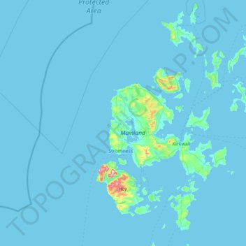
Nom : Carte topographique Archipel des Orcades, altitude, relief.
Lieu : Archipel des Orcades, Orkney Islands, Écosse, Royaume-Uni (58.68595 -3.43586 59.39272 -2.37048)
Altitude moyenne : 9 m
Altitude minimum : -1 m
Altitude maximum : 475 m
Autres cartes topographiques
Cliquez sur une carte pour visualiser sa topographie, son altitude et son relief.