Géolocaliser

Carte topographique Nyeri

Carte interactive

Cliquez sur la carte pour afficher l’altitude.

À propos de cette carte

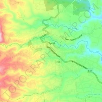
Nom : Carte topographique Nyeri, altitude, relief.

Lieu : Nyeri, Nyeri Central, Nyeri, Central Kenya, Kenya (-0.44526 36.90774 -0.40563 36.98616)

Altitude moyenne : 1 796 m

Altitude minimum : 1 654 m

Altitude maximum : 2 013 m

Nyeri has tarmacked roads, and the county and national governments are upgrading many of them. Houses have drinking water on tap, but sewage provision is through soak pits, pit latrines and septic tanks are still widespread. The city's topography allows nature and gravity to take care of most of the city's storm water drainage.

Wikipedia (CC-BY-SA 3.0)