
Carte topographique Leh
Carte interactive
Cliquez sur la carte pour afficher l’altitude.
Leh
Située à 3 500 m d'altitude, dans la vallée de l'Indus, Leh est la capitale et la plus importante ville de la région du Ladakh.
À propos de cette carte
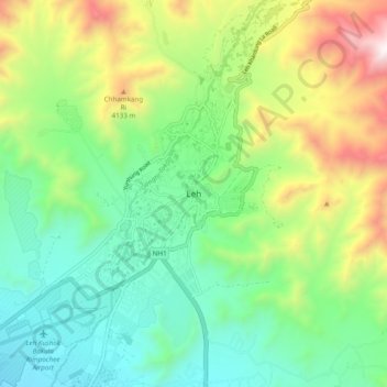
Nom : Carte topographique Leh, altitude, relief.
Lieu : Leh, Leh district, Ladakh, Inde (34.12420 77.54481 34.20420 77.62481)
Altitude moyenne : 3 653 m
Altitude minimum : 3 206 m
Altitude maximum : 4 572 m
Autres cartes topographiques
Cliquez sur une carte pour visualiser sa topographie, son altitude et son relief.
Kargil district old
À une altitude moyenne de 2 676 mètres, la ville se situe au bord des rives du Suru.
Altitude moyenne : 4 214 m
Nubra
La rivière Shyok rencontre la rivière Noubra (ou rivière Siachan) pour former une grande vallée qui sépare les chaînes du Ladakh et du Karakoram. La rivière Shyok est un affluent de la rivière Indus. L'altitude moyenne de la vallée est de plus de 3 000 m. Le moyen commun d'accéder à cette vallée…
Altitude moyenne : 4 978 m