Géolocaliser

Carte topographique Hue City

Carte interactive

Cliquez sur la carte pour afficher l’altitude.

À propos de cette carte
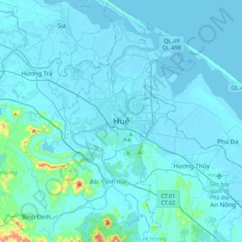
Nom : Carte topographique Hue City, altitude, relief.

Lieu : Hue City, Thừa Thiên Huế Province, 54000, Vietnam (16.32253 107.46826 16.60368 107.67605)

Altitude moyenne : 24 m

Altitude minimum : -2 m

Altitude maximum : 489 m

Located near Truong Son mountain range, Hue city is a plain area in the lower reaches of the Perfume and Bo rivers, with an average altitude of 3–4 m above sea level and often flooded when the river's headwaters Huong has medium and large rainfall. This plain area is relatively flat, although there are alternating hills and low mountains such as Ngu Binh mountain and Vong Canh Hill.

Wikipedia (CC-BY-SA 3.0)