Carte topographique Ojai
Carte interactive
Cliquez sur la carte pour afficher l’altitude.
À propos de cette carte
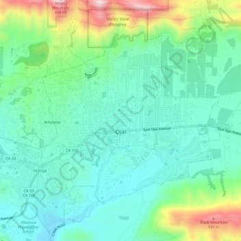
Nom : Carte topographique Ojai, altitude, relief.
Lieu : Ojai, Ventura County, California, 93023, United States (34.42924 -119.27457 34.47065 -119.22062)
Altitude moyenne : 289 m
Altitude minimum : 180 m
Altitude maximum : 592 m
Nordhoff Ridge, the western extension of the Topatopa Mountains, towers over the north side of the valley at more than 5,000 feet (1,500 m). Sulphur Mountain creates the southern ranges bounding the Ojai Valley, a little under 3,000 feet (910 m) in elevation. The Sulphur and Topatopa mountains are part of the Transverse Ranges system. The Ojai Valley and the surrounding mountains are heavily wooded with oak trees.
Autres cartes topographiques
Cliquez sur une carte pour visualiser sa topographie, son altitude et son relief.
Oak View
United States > California > Ventura County
Oak View, Ventura County, CAL Fire Southern Region, California, 93022, United States
Altitude moyenne : 184 m
Jasmine Glen Estates
United States > California > Ventura County > Simi Valley
Jasmine Glen Estates, Simi Valley, Ventura County, CAL Fire Southern Region, California, 90363, United States
Altitude moyenne : 331 m
San Buenaventura (Ventura)
United States > California > Ventura County
San Buenaventura (Ventura), Ventura County, CAL Fire Southern Region, California, United States
Altitude moyenne : 158 m
SSFL South Buffer
United States > California > Ventura County
SSFL South Buffer, Ventura County, CAL Fire Contract Counties, California, United States
Altitude moyenne : 504 m
Port Hueneme
United States > California > Ventura County
Port Hueneme, Ventura County, CAL Fire Southern Region, California, United States
Altitude moyenne : 7 m
Lake Sherwood
United States > California > Ventura County
Lake Sherwood, Ventura County, California, United States
Altitude moyenne : 332 m
Newbury Park
United States > California > Ventura County > Thousand Oaks > Newbury Park
Newbury Park, Thousand Oaks, Ventura County, California, 91320, United States
Altitude moyenne : 262 m
Somis
United States > California > Ventura County
Somis, Ventura County, CAL Fire Southern Region, California, 93066, United States
Altitude moyenne : 112 m
Simi Valley
United States > California > Ventura County > Simi Valley
Simi Valley, Ventura County, California, 93063-2364, United States
Altitude moyenne : 379 m
Simi Valley
United States > California > Ventura County
Simi Valley, Ventura County, California, United States
Altitude moyenne : 405 m
Thousand Oaks
United States > California > Ventura County
Thousand Oaks, Ventura County, California, United States
Altitude moyenne : 333 m
Strathearn
United States > California > Ventura County > Simi Valley
Strathearn, Simi Valley, Ventura County, CAL Fire Southern Region, California, 93065, United States
Altitude moyenne : 261 m
Santa Paula
United States > California > Ventura County
Santa Paula, Ventura County, CAL Fire Southern Region, California, United States
Altitude moyenne : 148 m
Greenwich Village
United States > California > Ventura County > Thousand Oaks > Greenwich Village
Greenwich Village, Thousand Oaks, Ventura County, California, 91360-4401, United States
Altitude moyenne : 275 m
Casitas Springs
United States > California > Ventura County > Ventura > Casitas Springs
Casitas Springs, Ventura, Ventura County, California, 93022, United States
Altitude moyenne : 182 m
Johnson Creek Park
United States > California > Ventura County > Oxnard > Pleasant Valley Mobile Home Park
Johnson Creek Park, Pleasant Valley Mobile Home Park, Oxnard, Ventura County, California, United States
Altitude moyenne : 10 m
Oxnard
United States > California > Ventura County
Oxnard, Ventura County, California, United States
Altitude moyenne : 16 m
Anacapa Island
United States > California > Ventura County
Anacapa Island, Ventura County, California, United States
Altitude moyenne : 4 m
Thousand Oaks
United States > California > Ventura County > Thousand Oaks
Thousand Oaks, Ventura County, California, United States
Altitude moyenne : 303 m
Ventura
United States > California > Ventura County
Ventura, Ventura County, CAL Fire Southern Region, California, United States
Altitude moyenne : 120 m
Camarillo
United States > California > Ventura County
Camarillo, Ventura County, CAL Fire Southern Region, California, United States
Altitude moyenne : 90 m