
Carte topographique Bulle
Carte interactive
Cliquez sur la carte pour afficher l’altitude.
Bulle
Située à environ 750 mètres d'altitude, la ville originelle s'étend sur une butte entourée de terrains marécageux, comme en témoignent les lieux-dits aux alentours: Palud, Léchère par exemple. Les quartiers modernes s'étendent de part et d'autre de cette butte, vers les contreforts de la Chia à l'ouest et sur la colline de Jéricho à l'est. Cependant, la ville de Bulle n'occupe de loin pas tout l'espace de la commune. Celle-ci couvre un territoire qui va des bords de la Sarine au pied du Moléson. Le point le plus bas de la commune (au bord de la Sarine) est à 679 mètres d'altitude, tandis que le point le plus haut culmine à 1 390 mètres d'altitude, sur la colline de la Chia.
À propos de cette carte
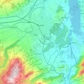
Nom : Carte topographique Bulle, altitude, relief.
Lieu : Bulle, District de la Gruyère, Fribourg, Suisse (46.56952 6.99339 46.64054 7.09527)
Altitude moyenne : 834 m
Altitude minimum : 665 m
Altitude maximum : 1 383 m
Autres cartes topographiques
Cliquez sur une carte pour visualiser sa topographie, son altitude et son relief.
Dent de Brenleire
Suisse > Fribourg > District de la Gruyère > Val-de-Charmey
Altitude moyenne : 1 734 m
Charmey (Gruyère)
Suisse > Fribourg > District de la Gruyère > Val-de-Charmey
Une station de sports d'hiver - le plus vaste domaine skiable des Préalpes fribourgeoises - a été aménagée sur le territoire de la commune, sur les pentes de la montagne Vounetz. La télécabine 8 places, construite en 1962 puis reconstruite en 1998, part directement du village à 870 m d'altitude, et…
Altitude moyenne : 1 029 m