
Carte topographique Roche Béranger
Carte interactive
Cliquez sur la carte pour afficher l’altitude.
Roche Béranger
Chamrousse est une commune française située géographiquement en altitude dans les Alpes à l'extrémité sud de la chaîne de Belledonne, au-dessus de la vallée du Grésivaudan et de l'agglomération grenobloise, administrativement dans le département de l'Isère, en région Auvergne-Rhône-Alpes et autrefois rattachée à l'ancienne province du Dauphiné.
À propos de cette carte
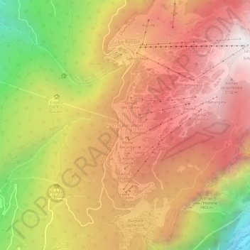
Nom : Carte topographique Roche Béranger, altitude, relief.
Altitude moyenne : 1 561 m
Altitude minimum : 539 m
Altitude maximum : 2 250 m