
Carte topographique Lac Louisa
Carte interactive
Cliquez sur la carte pour afficher l’altitude.
À propos de cette carte
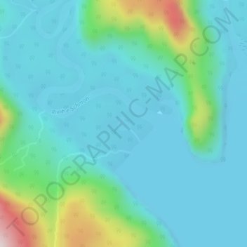
Nom : Carte topographique Lac Louisa, altitude, relief.
Altitude moyenne : 201 m
Altitude minimum : 111 m
Altitude maximum : 590 m
Autres cartes topographiques
Cliquez sur une carte pour visualiser sa topographie, son altitude et son relief.
Lac Serpent
Canada > Québec > Sept-Rivières > Lac-Walker
Lac Serpent, Lac-Walker, Sept-Rivières, Côte-Nord, Québec, Canada
Altitude moyenne : 476 m
Lac Roger
Canada > Québec > Sept-Rivières > Lac-Walker
Lac Roger, Lac-Walker, Sept-Rivières, Côte-Nord, Québec, Canada
Altitude moyenne : 246 m
Lac Veillette
Canada > Québec > Sept-Rivières > Lac-Walker
Lac Veillette, Lac-Walker, Sept-Rivières, Côte-Nord, Québec, Canada
Altitude moyenne : 316 m
Lac-Walker
Canada > Québec > Sept-Rivières > Lac-Walker
Lac-Walker, Sept-Rivières, Côte-Nord, Québec, Canada
Altitude moyenne : 434 m
Lac Arthur
Canada > Québec > Sept-Rivières > Lac-Walker
Lac Arthur, Lac-Walker, Sept-Rivières, Côte-Nord, Québec, Canada
Altitude moyenne : 514 m
Lac Louisa
Canada > Québec > Sept-Rivières > Lac-Walker
Lac Louisa, Lac-Walker, Sept-Rivières, Côte-Nord, Québec, Canada
Altitude moyenne : 201 m
Lac Francis
Canada > Québec > Sept-Rivières > Lac-Walker
Lac Francis, Lac-Walker, Sept-Rivières, Côte-Nord, Québec, Canada
Altitude moyenne : 661 m
Lac Perle
Canada > Québec > Sept-Rivières > Lac-Walker
Lac Perle, Lac-Walker, Sept-Rivières, Côte-Nord, Québec, Canada
Altitude moyenne : 312 m