Géolocaliser

Carte topographique Tianjin

Carte interactive

Cliquez sur la carte pour afficher l’altitude.

À propos de cette carte

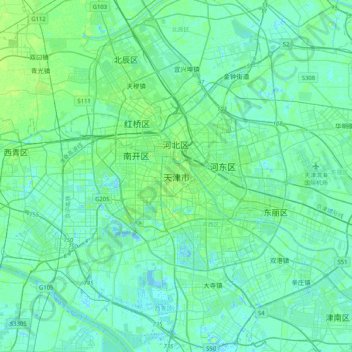
Nom : Carte topographique Tianjin, altitude, relief.

Lieu : Tianjin, 300061, China (38.92480 117.03599 39.24480 117.35599)

Altitude moyenne : 4 m

Altitude minimum : -5 m

Altitude maximum : 21 m

There is 153 km (95 mi) of coastline and 1,137.48 kilometers (706.80 mi) of land border. It lies at the northern end of the Grand Canal of China, which connects with the Yellow River and Yangtze River. The municipality is generally flat, and swampy near the coast, but hilly in the far north, where the Yan Mountains intrude into northern Tianjin. Extensive tidal flats occur on the coastal plain adjacent to the city. The highest point in the municipality is Jiuding Peak (九顶山) in Ji County on the northern border with Hebei, at an altitude of 1,078.5 m (3,538 ft).

Wikipedia (CC-BY-SA 3.0)