
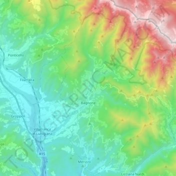
Carte topographique Bagnone
Carte interactive
Cliquez sur la carte pour afficher l’altitude.
À propos de cette carte
Nom : Carte topographique Bagnone, altitude, relief.
Altitude moyenne : 568 m
Altitude minimum : 91 m
Altitude maximum : 1 841 m
Autres cartes topographiques
Cliquez sur une carte pour visualiser sa topographie, son altitude et son relief.
Île de Pianosa
Italie > Toscane > Livourne > Pianosa
Le nom donné par les phocéens à l'île est Planasia en grec ancien, qui donné ensuite Pianosa, en raison de la faible élévation de l’ile. En effet, son point le plus élevé se trouve à seulement 29 mètres au-dessus du niveau de la mer. L'île de Planier, en face de Marseille partage la même…
Altitude moyenne : 5 m
Camellietum Compitese
Italie > Toscane > Lucques > Capannori > Sant'Andrea di Compito
Altitude moyenne : 271 m
Collodi
Italie > Toscane > Pistoia > Pescia
Collodi, village de moyenne montagne de l'Appennino pistoiese, altitude 125 mètres, est un des hameaux de Pescia (chef-lieu, altitude 62 mètres) qui comprend également les autres hameaux suivants qui se situent à une altitude variant de 60 à 750 mètres : Aramo, Castellare, Castelvecchio, Fibbialla,…
Altitude moyenne : 232 m