
Faire un don
Équipez-vous pour votre prochaine aventure :
En tant que Partenaire Amazon, ce site perçoit une commission sur les achats éligibles sans surcoût pour vous.
Carte topographique Area J (Copper Desert Country)
Cliquez sur la carte pour afficher l’altitude.
Faire un don
Équipez-vous pour votre prochaine aventure :
En tant que Partenaire Amazon, ce site perçoit une commission sur les achats éligibles sans surcoût pour vous.
À propos de cette carte
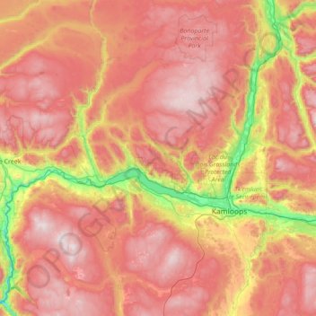
Nom : Carte topographique Area J (Copper Desert Country), altitude, relief.
Altitude moyenne : 1 128 m
Altitude minimum : 220 m
Altitude maximum : 1 986 m
Faire un don
Équipez-vous pour votre prochaine aventure :
En tant que Partenaire Amazon, ce site perçoit une commission sur les achats éligibles sans surcoût pour vous.
Autres cartes topographiques
Cliquez sur une carte pour visualiser sa topographie, son altitude et son relief.
70 Mile House
Canada > British Columbia > Thompson-Nicola Regional District > Area E (Bonaparte Plateau)
Altitude moyenne : 1 087 m
Kamloops
Canada > British Columbia > Thompson-Nicola Regional District > Kamloops
Altitude moyenne : 875 m
South Thompson River
Canada > British Columbia > Thompson-Nicola Regional District > Kamloops
Altitude moyenne : 421 m
Wasley Lake
Canada > British Columbia > Thompson-Nicola Regional District > Area M (Beautiful Nicola Valley - North)
Altitude moyenne : 1 291 m
Faire un don
Équipez-vous pour votre prochaine aventure :
En tant que Partenaire Amazon, ce site perçoit une commission sur les achats éligibles sans surcoût pour vous.
Sun Peaks Mountain Resort Municipality
Canada > British Columbia > Thompson-Nicola Regional District
Altitude moyenne : 1 589 m
Little Fort
Canada > British Columbia > Thompson-Nicola Regional District > Area O (Lower North Thompson)
Altitude moyenne : 521 m
Thompson River
Canada > British Columbia > Thompson-Nicola Regional District
Altitude moyenne : 1 127 m
Spectacle Lake
Canada > British Columbia > Thompson-Nicola Regional District > Area O (Lower North Thompson)
Altitude moyenne : 1 428 m
Faire un don
Équipez-vous pour votre prochaine aventure :
En tant que Partenaire Amazon, ce site perçoit une commission sur les achats éligibles sans surcoût pour vous.
Knouff Lake
Canada > British Columbia > Thompson-Nicola Regional District > Area P (Rivers and the Peaks)
Altitude moyenne : 1 249 m
Brookmere
Canada > British Columbia > Thompson-Nicola Regional District > Area N (Beautiful Nicola Valley - South)
Altitude moyenne : 1 152 m
Mount Tod
Canada > British Columbia > Thompson-Nicola Regional District > Sun Peaks Mountain Resort Municipality
Altitude moyenne : 1 925 m
Vimy Ridge
Canada > British Columbia > Thompson-Nicola Regional District > Area A (Wells Gray Country)
Altitude moyenne : 1 871 m
Faire un don
Équipez-vous pour votre prochaine aventure :
En tant que Partenaire Amazon, ce site perçoit une commission sur les achats éligibles sans surcoût pour vous.
Mount St. Anne
Canada > British Columbia > Thompson-Nicola Regional District > Area B (Thompson Headwaters)
Altitude moyenne : 1 901 m
Dragon Cone
Canada > British Columbia > Thompson-Nicola Regional District > Area A (Wells Gray Country)
Altitude moyenne : 1 703 m
Bleeker Lake
Canada > British Columbia > Thompson-Nicola Regional District > Area L (Grasslands)
Altitude moyenne : 1 148 m
Ernest Lake
Canada > British Columbia > Thompson-Nicola Regional District > Area L (Grasslands)
Altitude moyenne : 1 260 m
Faire un don
Équipez-vous pour votre prochaine aventure :
En tant que Partenaire Amazon, ce site perçoit une commission sur les achats éligibles sans surcoût pour vous.
Paul Lake
Canada > British Columbia > Thompson-Nicola Regional District > Area P (Rivers and the Peaks)
Altitude moyenne : 926 m
Clifford Lake
Canada > British Columbia > Thompson-Nicola Regional District > Area N (Beautiful Nicola Valley - South)
Altitude moyenne : 1 085 m
Savona
Canada > British Columbia > Thompson-Nicola Regional District > Area J (Copper Desert Country)
Altitude moyenne : 480 m
Sun Peaks
Canada > British Columbia > Thompson-Nicola Regional District > Sun Peaks Mountain Resort Municipality
Altitude moyenne : 1 490 m
Faire un don
Équipez-vous pour votre prochaine aventure :
En tant que Partenaire Amazon, ce site perçoit une commission sur les achats éligibles sans surcoût pour vous.
Powerline Lake
Canada > British Columbia > Thompson-Nicola Regional District > Area L (Grasslands)
Altitude moyenne : 1 215 m
Monte Lake
Canada > British Columbia > Thompson-Nicola Regional District > Area L (Grasslands)
Altitude moyenne : 862 m
Eleanor Lake
Canada > British Columbia > Thompson-Nicola Regional District > Area B (Thompson Headwaters) > Blue River
Altitude moyenne : 695 m
Jacko Lake
Canada > British Columbia > Thompson-Nicola Regional District > Area J (Copper Desert Country)
Altitude moyenne : 931 m
Faire un don
Équipez-vous pour votre prochaine aventure :
En tant que Partenaire Amazon, ce site perçoit une commission sur les achats éligibles sans surcoût pour vous.
Snohoosh Lake
Canada > British Columbia > Thompson-Nicola Regional District > Area J (Copper Desert Country)
Altitude moyenne : 1 000 m
Stake Lake
Canada > British Columbia > Thompson-Nicola Regional District > Area J (Copper Desert Country)
Altitude moyenne : 1 351 m
Mount Cahilty
Canada > British Columbia > Thompson-Nicola Regional District > Area O (Lower North Thompson)
Altitude moyenne : 1 736 m
Whitecroft
Canada > British Columbia > Thompson-Nicola Regional District > Area P (Rivers and the Peaks)
Altitude moyenne : 1 000 m
Faire un don
Équipez-vous pour votre prochaine aventure :
En tant que Partenaire Amazon, ce site perçoit une commission sur les achats éligibles sans surcoût pour vous.
Pinantan Lake
Canada > British Columbia > Thompson-Nicola Regional District > Area P (Rivers and the Peaks)
Altitude moyenne : 971 m
Dominic Lake
Canada > British Columbia > Thompson-Nicola Regional District > Area J (Copper Desert Country)
Altitude moyenne : 1 583 m
Cultus Lake
Canada > British Columbia > Thompson-Nicola Regional District > Area J (Copper Desert Country)
Altitude moyenne : 1 033 m
Drum Lake
Canada > British Columbia > Thompson-Nicola Regional District > Area M (Beautiful Nicola Valley - North)
Altitude moyenne : 1 166 m
Faire un don
Équipez-vous pour votre prochaine aventure :
En tant que Partenaire Amazon, ce site perçoit une commission sur les achats éligibles sans surcoût pour vous.
Kingsvale
Canada > British Columbia > Thompson-Nicola Regional District > Area N (Beautiful Nicola Valley - South)
Altitude moyenne : 928 m
Leonie Lake
Canada > British Columbia > Thompson-Nicola Regional District > Area O (Lower North Thompson)
Altitude moyenne : 1 107 m
Lower Nicola
Canada > British Columbia > Thompson-Nicola Regional District > Area M (Beautiful Nicola Valley - North)
Altitude moyenne : 649 m
Vavenby
Canada > British Columbia > Thompson-Nicola Regional District > Area A (Wells Gray Country)
Altitude moyenne : 642 m
Faire un don
Équipez-vous pour votre prochaine aventure :
En tant que Partenaire Amazon, ce site perçoit une commission sur les achats éligibles sans surcoût pour vous.
Courtney Lake
Canada > British Columbia > Thompson-Nicola Regional District > Area N (Beautiful Nicola Valley - South)
Altitude moyenne : 1 028 m
McConnell Lake Provincial Park
Canada > British Columbia > Thompson-Nicola Regional District > Area J (Copper Desert Country)
Altitude moyenne : 1 329 m
Dagger Lake
Canada > British Columbia > Thompson-Nicola Regional District > Area O (Lower North Thompson)
Altitude moyenne : 1 484 m
Edna Lake
Canada > British Columbia > Thompson-Nicola Regional District > Area N (Beautiful Nicola Valley - South)
Altitude moyenne : 1 304 m
Faire un don
Équipez-vous pour votre prochaine aventure :
En tant que Partenaire Amazon, ce site perçoit une commission sur les achats éligibles sans surcoût pour vous.
Pritchard
Canada > British Columbia > Thompson-Nicola Regional District > Area P (Rivers and the Peaks)
Altitude moyenne : 433 m
Dunn Peak
Canada > British Columbia > Thompson-Nicola Regional District > Area O (Lower North Thompson)
Altitude moyenne : 2 132 m
Davis Lake Recreation Site
Canada > British Columbia > Thompson-Nicola Regional District > Area N (Beautiful Nicola Valley - South)
Altitude moyenne : 1 123 m
Brenda Lake
Canada > British Columbia > Thompson-Nicola Regional District > Area M (Beautiful Nicola Valley - North)
Altitude moyenne : 1 753 m
Faire un don
Équipez-vous pour votre prochaine aventure :
En tant que Partenaire Amazon, ce site perçoit une commission sur les achats éligibles sans surcoût pour vous.
Mount Knouff
Canada > British Columbia > Thompson-Nicola Regional District > Area P (Rivers and the Peaks)
Altitude moyenne : 1 225 m
Blue River
Canada > British Columbia > Thompson-Nicola Regional District > Area B (Thompson Headwaters)
Altitude moyenne : 710 m
Pillar Lake
Canada > British Columbia > Thompson-Nicola Regional District > Area L (Grasslands)
Altitude moyenne : 1 021 m
Spider Lake
Canada > British Columbia > Thompson-Nicola Regional District > Area O (Lower North Thompson)
Altitude moyenne : 1 358 m
Faire un don
Équipez-vous pour votre prochaine aventure :
En tant que Partenaire Amazon, ce site perçoit une commission sur les achats éligibles sans surcoût pour vous.
Kanaka Bar
Canada > British Columbia > Thompson-Nicola Regional District > Kanaka Bar
Altitude moyenne : 345 m
Shaw Springs
Canada > British Columbia > Thompson-Nicola Regional District > Area I (Blue Sky Country)
Altitude moyenne : 472 m
Alleyne Lake
Canada > British Columbia > Thompson-Nicola Regional District > Area N (Beautiful Nicola Valley - South)
Altitude moyenne : 1 089 m
Lac Le Jeune
Canada > British Columbia > Thompson-Nicola Regional District > Area J (Copper Desert Country)
Altitude moyenne : 1 309 m
Faire un don
Équipez-vous pour votre prochaine aventure :
En tant que Partenaire Amazon, ce site perçoit une commission sur les achats éligibles sans surcoût pour vous.
Barnes Lake
Canada > British Columbia > Thompson-Nicola Regional District > Area I (Blue Sky Country)
Altitude moyenne : 752 m
Walhachin
Canada > British Columbia > Thompson-Nicola Regional District > Area I (Blue Sky Country)
In December 1914, the westward advance of the CNoR rail head from Kamloops reached Walhachin. The track follows the valley floor at a much lower elevation than the hamlet proper.
Altitude moyenne : 438 m
Westwold
Canada > British Columbia > Thompson-Nicola Regional District > Area L (Grasslands)
Altitude moyenne : 649 m
Strait Lake
Canada > British Columbia > Thompson-Nicola Regional District > Area A (Wells Gray Country)
Altitude moyenne : 1 531 m
Faire un don
Équipez-vous pour votre prochaine aventure :
En tant que Partenaire Amazon, ce site perçoit une commission sur les achats éligibles sans surcoût pour vous.
Kentucky Lake
Canada > British Columbia > Thompson-Nicola Regional District > Area N (Beautiful Nicola Valley - South)
Altitude moyenne : 1 118 m
Fatox Lake
Canada > British Columbia > Thompson-Nicola Regional District > Area J (Copper Desert Country)
Altitude moyenne : 1 173 m
Riley Dam Recreation Site
Canada > British Columbia > Thompson-Nicola Regional District > Area E (Bonaparte Plateau)
Altitude moyenne : 1 077 m
Thompson Glacier
Canada > British Columbia > Thompson-Nicola Regional District > Area B (Thompson Headwaters)
Altitude moyenne : 2 313 m
Faire un don
Équipez-vous pour votre prochaine aventure :
En tant que Partenaire Amazon, ce site perçoit une commission sur les achats éligibles sans surcoût pour vous.
Separation Lake
Canada > British Columbia > Thompson-Nicola Regional District > Area L (Grasslands)
Altitude moyenne : 914 m
Valleyview Nature Park
Canada > British Columbia > Thompson-Nicola Regional District > Kamloops
Altitude moyenne : 429 m
Blue Earth Lake
Canada > British Columbia > Thompson-Nicola Regional District > Area I (Blue Sky Country)
Altitude moyenne : 1 525 m
Pat Lake
Canada > British Columbia > Thompson-Nicola Regional District > Area J (Copper Desert Country)
Altitude moyenne : 667 m
Faire un don
Équipez-vous pour votre prochaine aventure :
En tant que Partenaire Amazon, ce site perçoit une commission sur les achats éligibles sans surcoût pour vous.
Chasm
Canada > British Columbia > Thompson-Nicola Regional District > Area E (Bonaparte Plateau)
Altitude moyenne : 1 063 m
Little Green Lake
Canada > British Columbia > Thompson-Nicola Regional District > Area E (Bonaparte Plateau)
Altitude moyenne : 1 087 m
Spences Bridge
Canada > British Columbia > Thompson-Nicola Regional District > Area I (Blue Sky Country)
Spences Bridge's location is mountainous, with higher elevations part of the Interior Plateau. The east side of the Fraser here is part of the Clear Range, a mountainous southwards extension of the Fraser Plateau located in the angle of the Thompson and Fraser Rivers. Arthur Seat lies in that range on the west…
Altitude moyenne : 496 m
Fire Mountain
Canada > British Columbia > Thompson-Nicola Regional District > Area A (Wells Gray Country)
Kostal Cone, also called Kostal Volcano and Fire Mountain, is a young cinder cone in Wells Gray Provincial Park in east-central British Columbia, Canada. It rises from the northeast shore of Kostal Lake in the Cariboo Mountains. With an elevation of 1,440 m (4,724 ft), Kostal Cone is one of the lowest…
Altitude moyenne : 1 316 m
Faire un don
Équipez-vous pour votre prochaine aventure :
En tant que Partenaire Amazon, ce site perçoit une commission sur les achats éligibles sans surcoût pour vous.
McLeod Hill
Canada > British Columbia > Thompson-Nicola Regional District > Area A (Wells Gray Country)
Altitude moyenne : 1 133 m
Merritt
Canada > British Columbia > Thompson-Nicola Regional District > Merritt
Altitude moyenne : 1 099 m
Mount Morrisey
Canada > British Columbia > Thompson-Nicola Regional District > Sun Peaks Mountain Resort Municipality
Altitude moyenne : 1 516 m
Nicola
Canada > British Columbia > Thompson-Nicola Regional District > Area M (Beautiful Nicola Valley - North) > Nicola
Altitude moyenne : 713 m
Faire un don
Équipez-vous pour votre prochaine aventure :
En tant que Partenaire Amazon, ce site perçoit une commission sur les achats éligibles sans surcoût pour vous.
Sparks Lake
Canada > British Columbia > Thompson-Nicola Regional District > Area J (Copper Desert Country)
Altitude moyenne : 1 016 m
Courtney Lake
Canada > British Columbia > Thompson-Nicola Regional District > Area N (Beautiful Nicola Valley - South)
Altitude moyenne : 1 048 m
Hoodoos
Canada > British Columbia > Thompson-Nicola Regional District > Area J (Copper Desert Country)
Altitude moyenne : 469 m
Porcupine Ridge
Canada > British Columbia > Thompson-Nicola Regional District > Area J (Copper Desert Country)
Altitude moyenne : 1 798 m
Faire un don
Équipez-vous pour votre prochaine aventure :
En tant que Partenaire Amazon, ce site perçoit une commission sur les achats éligibles sans surcoût pour vous.
Highland Valley
Canada > British Columbia > Thompson-Nicola Regional District > Logan Lake
Altitude moyenne : 1 190 m
Glimpse Lake
Canada > British Columbia > Thompson-Nicola Regional District > Area M (Beautiful Nicola Valley - North)
Altitude moyenne : 1 211 m
Allen Meadows Lake
Canada > British Columbia > Thompson-Nicola Regional District > Area J (Copper Desert Country)
Altitude moyenne : 1 214 m
Aspen Grove
Canada > British Columbia > Thompson-Nicola Regional District > Area N (Beautiful Nicola Valley - South)
Altitude moyenne : 1 165 m
Faire un don
Équipez-vous pour votre prochaine aventure :
En tant que Partenaire Amazon, ce site perçoit une commission sur les achats éligibles sans surcoût pour vous.
Greenstone Mountain
Canada > British Columbia > Thompson-Nicola Regional District > Area J (Copper Desert Country)
Altitude moyenne : 1 624 m
Blackstone Glacier
Canada > British Columbia > Thompson-Nicola Regional District > Area B (Thompson Headwaters)
Altitude moyenne : 2 368 m
Black Dome Mountain
Canada > British Columbia > Thompson-Nicola Regional District > Area E (Bonaparte Plateau)
Altitude moyenne : 1 931 m
Lower Nicola
Canada > British Columbia > Thompson-Nicola Regional District > Area M (Beautiful Nicola Valley - North)
Altitude moyenne : 649 m
Faire un don
Équipez-vous pour votre prochaine aventure :
En tant que Partenaire Amazon, ce site perçoit une commission sur les achats éligibles sans surcoût pour vous.
Roper Hill
Canada > British Columbia > Thompson-Nicola Regional District > Area J (Copper Desert Country)
Altitude moyenne : 486 m
Quilchena
Canada > British Columbia > Thompson-Nicola Regional District > Area M (Beautiful Nicola Valley - North)
Altitude moyenne : 677 m
Sun Peaks
Canada > British Columbia > Thompson-Nicola Regional District > Sun Peaks Mountain Resort Municipality
Altitude moyenne : 1 490 m
Sun Peaks
Canada > British Columbia > Thompson-Nicola Regional District > Sun Peaks Mountain Resort Municipality
Altitude moyenne : 1 490 m
Faire un don
Équipez-vous pour votre prochaine aventure :
En tant que Partenaire Amazon, ce site perçoit une commission sur les achats éligibles sans surcoût pour vous.
Arthur Seat
Canada > British Columbia > Thompson-Nicola Regional District > Area I (Blue Sky Country)
Altitude moyenne : 1 327 m
Spences Bridge
Canada > British Columbia > Thompson-Nicola Regional District > Area I (Blue Sky Country)
Spences Bridge's location is mountainous, with higher elevations part of the Interior Plateau. The east side of the Fraser here is part of the Clear Range, a mountainous southwards extension of the Fraser Plateau located in the angle of the Thompson and Fraser Rivers. Arthur Seat lies in that range on the west…
Altitude moyenne : 496 m
Sun Peaks
Canada > British Columbia > Thompson-Nicola Regional District > Sun Peaks Mountain Resort Municipality
Altitude moyenne : 1 490 m
Arthur Seat
Canada > British Columbia > Thompson-Nicola Regional District > Area I (Blue Sky Country)
Altitude moyenne : 1 327 m
Faire un don
Équipez-vous pour votre prochaine aventure :
En tant que Partenaire Amazon, ce site perçoit une commission sur les achats éligibles sans surcoût pour vous.