
Carte topographique Ausserberg
Carte interactive
Cliquez sur la carte pour afficher l’altitude.
Ausserberg
Ausserberg se situe dans le demi-district de Rarogne occidental, dans le canton du Valais, sur le flanc nord de la vallée du Rhône, entre le Baltschiederbach et le Bietschhorn. Le village de Trogdorf, à 1 008 m d'altitude, se trouve centre du territoire communal.
À propos de cette carte
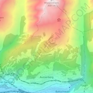
Nom : Carte topographique Ausserberg, altitude, relief.
Lieu : Ausserberg, Rarogne occidental, Valais, 3938, Suisse (46.30718 7.81901 46.35498 7.88132)
Altitude moyenne : 1 580 m
Altitude minimum : 638 m
Altitude maximum : 2 997 m
Autres cartes topographiques
Cliquez sur une carte pour visualiser sa topographie, son altitude et son relief.
Lötschenpass
Suisse > Valais > Rarogne occidental > Ferden
Le Lötschberg se trouve dans le sud-ouest de la Suisse, dans les Alpes bernoises, au sud de Thoune, au nord-est de Sierre et au nord-ouest de Viège et Brigue. Il s'agit d'une zone de montagne de la Lötschental — une vallée latérale à la vallée du Rhône —, entre environ 2 400 et 3 000 mètres…
Altitude moyenne : 2 683 m