
Carte topographique Serra de Tramuntana
Carte interactive
Cliquez sur la carte pour afficher l’altitude.
Serra de Tramuntana
Le point culminant du massif, le Puig Major, culmine à 1 436 mètres d'altitude à l'ouest de l'île ; c'est le plus haut sommet de Majorque ainsi que des îles Baléares. Il possède une antécime, le Penyal des Migdia (es) (1 386 m). Vient ensuite le Puig de Massanella (1 364 m) puis le Puig de Galatzó (es) avec 1 027 m.
À propos de cette carte
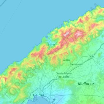
Nom : Carte topographique Serra de Tramuntana, altitude, relief.
Lieu : Serra de Tramuntana, Îles Baléares, Espagne (39.62579 2.44363 39.84761 2.96694)
Altitude moyenne : 175 m
Altitude minimum : -1 m
Altitude maximum : 1 418 m
Autres cartes topographiques
Cliquez sur une carte pour visualiser sa topographie, son altitude et son relief.