
Carte topographique Bangalore
Carte interactive
Cliquez sur la carte pour afficher l’altitude.
Bangalore
Bangalore bénéficie d'un climat tropical de mousson avec une saison des pluies bien marquée. La ville jouit d'un climat moins étouffant que la majeure partie des villes indiennes en raison de son altitude assez élevée. Cependant des vagues de forte chaleur ne sont pas à exclure. Le mois le plus froid est décembre avec une température moyenne de 18,7 °C et le mois le plus chaud celui d'avril avec une température moyenne de 28,0 °C. La température la plus haute enregistrée est de 38,9 °C tandis que la plus basse est de 7,8 °C (janvier 1884). La ville est exposée à la fois à la mousson du sud-ouest et à celle du nord-ouest et le mois le plus arrosé est septembre avec un maximum de hauteur de pluie de 244 mm. Le record de précipitations reçues en 24 heures est de 179 mm en date du 1er octobre 1997.
À propos de cette carte
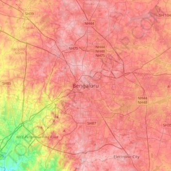
Nom : Carte topographique Bangalore, altitude, relief.
Altitude moyenne : 879 m
Altitude minimum : 712 m
Altitude maximum : 968 m