
Carte topographique Kittilä
Carte interactive
Cliquez sur la carte pour afficher l’altitude.
À propos de cette carte
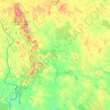
Nom : Carte topographique Kittilä, altitude, relief.
Altitude moyenne : 254 m
Altitude minimum : 129 m
Altitude maximum : 806 m
Autres cartes topographiques
Cliquez sur une carte pour visualiser sa topographie, son altitude et son relief.
Kilpisjärvi
Kilpisjärvi est à 15 kilomètres environ du tripoint avec la Suède et la Norvège, matérialisé par le Cairn des trois royaumes. C'est le troisième plus important village de la commune, après Hetta et Kaaresuvanto, sa population stagne autour de 110-120 habitants majoritairement Saamis. C'est aussi un…
Altitude moyenne : 527 m