
Faire un don
Équipez-vous pour votre prochaine aventure :
En tant que Partenaire Amazon, ce site perçoit une commission sur les achats éligibles sans surcoût pour vous.
Carte topographique Champoussin
Cliquez sur la carte pour afficher l’altitude.
Faire un don
Équipez-vous pour votre prochaine aventure :
En tant que Partenaire Amazon, ce site perçoit une commission sur les achats éligibles sans surcoût pour vous.
À propos de cette carte
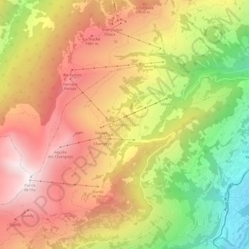
Nom : Carte topographique Champoussin, altitude, relief.
Lieu : Champoussin, Val-d'Illiez, Monthey, Valais, 1873, Suisse (46.18829 6.84285 46.22829 6.88285)
Altitude moyenne : 1 572 m
Altitude minimum : 865 m
Altitude maximum : 2 149 m
Faire un don
Équipez-vous pour votre prochaine aventure :
En tant que Partenaire Amazon, ce site perçoit une commission sur les achats éligibles sans surcoût pour vous.
Autres cartes topographiques
Cliquez sur une carte pour visualiser sa topographie, son altitude et son relief.
Monthey
Monthey se situe dans le district de Monthey, dont elle est le chef-lieu, dans le canton du Valais. La ville de Monthey se situe à l'extrémité du val d'Illiez, sur un cône alluvial de la Vièze, avant qu'elle se jette dans le Rhône. La commune se trouve dans la région du Chablais, sur le versant ouest de…
Altitude moyenne : 933 m
Collombey-Muraz
Le point culminant du territoire communal, La Pointe de Bellevue à 2 042 m d'altitude, offre une vue du lac Léman aux dents du Midi. Depuis 2013, ce sommet donne son nom à une course pédestre populaire.
Altitude moyenne : 562 m
Faire un don
Équipez-vous pour votre prochaine aventure :
En tant que Partenaire Amazon, ce site perçoit une commission sur les achats éligibles sans surcoût pour vous.
Vouvry
Le territoire de Vouvry s'étend sur 33,5 km2. Lors du relevé de 2013-2018, les surfaces d'habitations et d'infrastructures représentaient 6,6 % de sa superficie, les surfaces agricoles 34,9 %, les surfaces boisées 39,2 % et les surfaces improductives 19,2 %. La commune forme sur 7 km la frontière entre la…
Altitude moyenne : 847 m
Troistorrents
Troistorrents est une commune suisse du canton du Valais, située dans le district de Monthey. Elle occupe une partie du val d'Illiez et la plus grande partie du val de Morgins. Troistorrents, village chef-lieu, est situé à 765 m d'altitude. On peut s'y rendre par route ou en prenant le train de l'AOMC en…
Altitude moyenne : 1 231 m
Faire un don
Équipez-vous pour votre prochaine aventure :
En tant que Partenaire Amazon, ce site perçoit une commission sur les achats éligibles sans surcoût pour vous.
Monthey
Monthey se situe dans le district de Monthey, dont elle est le chef-lieu, dans le canton du Valais. La ville de Monthey se situe à l'extrémité du val d'Illiez, sur un cône alluvial de la Vièze, avant qu'elle se jette dans le Rhône. La commune se trouve dans la région du Chablais, sur le versant ouest de…
Altitude moyenne : 933 m
Troistorrents
Troistorrents est une commune suisse du canton du Valais, située dans le district de Monthey. Elle occupe une partie du val d'Illiez et la plus grande partie du val de Morgins. Troistorrents, village chef-lieu, est situé à 765 m d'altitude. On peut s'y rendre par route ou en prenant le train de l'AOMC en…
Altitude moyenne : 1 231 m
Faire un don
Équipez-vous pour votre prochaine aventure :
En tant que Partenaire Amazon, ce site perçoit une commission sur les achats éligibles sans surcoût pour vous.
Collombey-Muraz
Le point culminant du territoire communal, La Pointe de Bellevue à 2 042 m d'altitude, offre une vue du lac Léman aux dents du Midi. Depuis 2013, ce sommet donne son nom à une course pédestre populaire.
Altitude moyenne : 562 m
Dents du Midi
Suisse > Valais > Monthey > Val-d'Illiez
Les dents du Midi se situent à la limite entre les communes de Val-d'Illiez et d'Evionnaz. La face nord s'élève au-dessus du val d'Illiez tandis que la face sud domine le lac de Salanfe. La crête du chaînon se situe à une altitude variant entre 2 997 mètres et 3 257 mètres ; elle est visible depuis…
Altitude moyenne : 2 440 m
Dents du Midi
Suisse > Valais > Monthey > Mex (VS)
Les dents du Midi se situent à la limite entre les communes de Val-d'Illiez et d'Evionnaz. La face nord s'élève au-dessus du val d'Illiez tandis que la face sud domine le lac de Salanfe. La crête du chaînon se situe à une altitude variant entre 2 997 mètres et 3 257 mètres ; elle est visible depuis…
Altitude moyenne : 2 440 m
Faire un don
Équipez-vous pour votre prochaine aventure :
En tant que Partenaire Amazon, ce site perçoit une commission sur les achats éligibles sans surcoût pour vous.
Lac Vert
Suisse > Valais > Monthey > Val-d'Illiez
C'est un petit lac de montagne situé à 1 971 mètres d'altitude, à proximité de la frontière française.
Altitude moyenne : 1 932 m
Lac Vert
Suisse > Valais > Monthey > Val-d'Illiez
C'est un petit lac de montagne situé à 1 971 mètres d'altitude, à proximité de la frontière française.
Altitude moyenne : 1 932 m
Monthey
La commune se trouve dans la région du Chablais, sur le versant ouest de la vallée du Rhône, à une altitude moyenne de 573 mètres ; le point le plus bas se situe à 384 mètres aux Rigoles de Monthey, et le point le plus haut est le sommet de la pointe de Chésery, dans le vallon de They, à 2 250…
Altitude moyenne : 933 m
Faire un don
Équipez-vous pour votre prochaine aventure :
En tant que Partenaire Amazon, ce site perçoit une commission sur les achats éligibles sans surcoût pour vous.
Vouvry
Le territoire de Vouvry s'étend sur 33,5 km2. Lors du relevé de 2013-2018, les surfaces d'habitations et d'infrastructures représentaient 6,6 % de sa superficie, les surfaces agricoles 34,9 %, les surfaces boisées 39,2 % et les surfaces improductives 19,2 %. La commune forme sur 7 km la frontière entre la…
Altitude moyenne : 847 m
Faire un don
Équipez-vous pour votre prochaine aventure :
En tant que Partenaire Amazon, ce site perçoit une commission sur les achats éligibles sans surcoût pour vous.