
Carte topographique Majorque
Carte interactive
Cliquez sur la carte pour afficher l’altitude.
À propos de cette carte
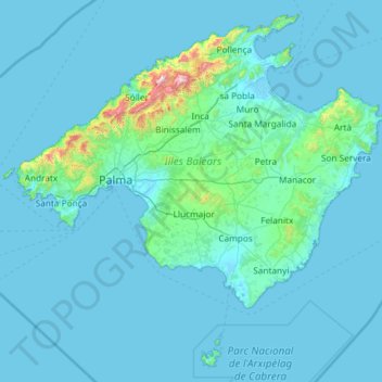
Nom : Carte topographique Majorque, altitude, relief.
Lieu : Majorque, Îles Baléares, Espagne (39.12073 2.30305 39.96251 3.47875)
Altitude moyenne : 57 m
Altitude minimum : -2 m
Altitude maximum : 1 368 m
Autres cartes topographiques
Cliquez sur une carte pour visualiser sa topographie, son altitude et son relief.
Puig Major
Espagne > Îles Baléares > Serra de Tramuntana > Escorca
Le Puig Major est le sommet le plus élevé de l'île de Majorque et des îles Baléares avec 1 436 mètres d'altitude. La montagne culmine sur la municipalité d'Escorca et s'étend également sur celle de Fornalutx. Son éperon sud s'appelle le Penyal des Migdia (es).
Altitude moyenne : 949 m
Serra de Tramuntana
Espagne > Îles Baléares > Serra de Tramuntana
Le point culminant du massif, le Puig Major, culmine à 1 436 mètres d'altitude à l'ouest de l'île ; c'est le plus haut sommet de Majorque ainsi que des îles Baléares. Il possède une antécime, le Penyal des Migdia (es) (1 386 m). Vient ensuite le Puig de Massanella (1 364 m) puis le Puig de Galatzó…
Altitude moyenne : 175 m
Mirador de ses Barques
Espagne > Îles Baléares > Serra de Tramuntana > Fornalutx
Altitude moyenne : 292 m
urbanització de Son Massip
Espagne > Îles Baléares > Serra de Tramuntana > Escorca > Lluc
Altitude moyenne : 687 m
Colònia de Sant Jordi
Espagne > Îles Baléares > Migjorn > ses Salines > Colònia de Sant Jordi
Altitude moyenne : 4 m
Urbanització des Guix
Espagne > Îles Baléares > Serra de Tramuntana > Escorca > Lluc
Altitude moyenne : 606 m
Estellencs
Espagne > Îles Baléares > Serra de Tramuntana > Estellencs > Estellencs
Altitude moyenne : 321 m
Passeig de ses fonts
Espagne > Îles Baléares > Ibiza > Sant Antoni de Portmany
Altitude moyenne : 14 m
Puig de Massanella
Espagne > Îles Baléares > Escorca
Le Puig de Massanella est le deuxième sommet le plus élevé de l'île de Majorque (en considérant comme une antécime le Penyal del Migdia, éperon sud du Puig Major) et des îles Baléares avec 1 364 mètres d'altitude. Cette montagne culmine sur la municipalité d'Escorca.
Altitude moyenne : 992 m