Géolocaliser

Carte topographique Yanqing District

Carte interactive

Cliquez sur la carte pour afficher l’altitude.

À propos de cette carte
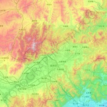
Nom : Carte topographique Yanqing District, altitude, relief.

Lieu : Yanqing District, Beijing, 102100, China (40.26430 115.72974 40.78988 116.56832)

Altitude moyenne : 806 m

Altitude minimum : 45 m

Altitude maximum : 2 199 m

The Yanqing Badaling Great Wall Basin is surrounded by mountains on three sides in the north, south, east, and Guanting Reservoir to the west, namely the Yanhuai Basin. Yanqing is located in the east of the basin, with an average elevation of about 500 meters. Haituo Mountain is the highest peak in the territory, with an elevation of 2241 meters and the second highest peak in Beijing.

Wikipedia (CC-BY-SA 3.0)

Autres cartes topographiques

Cliquez sur une carte pour visualiser sa topographie, son altitude et son relief.

Beijing

China > Beijing

Beijing, Dongcheng District, Beijing, 100010, China

Altitude moyenne : 47 m

Dongcheng District

China > Beijing > Dongcheng District

Beijing, Dongcheng District, Beijing, 100010, China

Altitude moyenne : 497 m