Géolocaliser

Carte topographique Saltillo

Carte interactive

Cliquez sur la carte pour afficher l’altitude.

À propos de cette carte

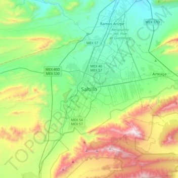
Nom : Carte topographique Saltillo, altitude, relief.

Lieu : Saltillo, Coahuila, 25000, Mexico (25.26304 -101.15275 25.58304 -100.83275)

Altitude moyenne : 1 857 m

Altitude minimum : 1 319 m

Altitude maximum : 3 119 m

El Cerro del Pueblo (The People's Hill) and its 4-metre (13 ft) cross overlook the city. The city's elevation makes it colder and windier than the neighboring city of Monterrey. Saltillo lies in the Chihuahuan Desert near the city of Arteaga. The city is flanked by the Zapalinamé mountains, which are part of the Sierra Madre Oriental. According to local legend, by looking at the relief of the mountains one can see the relief of Zapalinamé, chieftain of the Guachichil tribe.

Wikipedia (CC-BY-SA 3.0)