Géolocaliser

Carte topographique Beijing

Carte interactive

Cliquez sur la carte pour afficher l’altitude.

À propos de cette carte
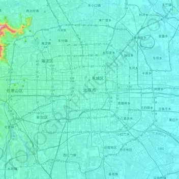
Nom : Carte topographique Beijing, altitude, relief.

Lieu : Beijing, Dongcheng District, Beijing, 100010, China (39.74571 116.23130 40.06571 116.55130)

Altitude moyenne : 47 m

Altitude minimum : 18 m

Altitude maximum : 509 m

Beijing is situated at the northern tip of the roughly triangular North China Plain, which opens to the south and east of the city. Mountains to the north, northwest and west shield the city and northern China's agricultural heartland from the encroaching desert steppes. The northwestern part of the municipality, especially Yanqing District and Huairou District, are dominated by the Jundu Mountains, while the western part is framed by Xishan or the Western Hills. The Great Wall of China across the northern part of Beijing Municipality was built on the rugged topography to defend against nomadic incursions from the steppes. Mount Dongling, in the Western Hills and on the border with Hebei, is the municipality's highest point, with an altitude of 2,303 metres (7,556 ft).

Wikipedia (CC-BY-SA 3.0)

Autres cartes topographiques

Cliquez sur une carte pour visualiser sa topographie, son altitude et son relief.

Haidian District

China > Beijing

Haidian District, Beijing, China

Altitude moyenne : 70 m

Shijingshan District

China > Beijing

Shijingshan District, Beijing, China

Altitude moyenne : 97 m