
Carte topographique Oural
Carte interactive
Cliquez sur la carte pour afficher l’altitude.
Oural
L’Oural ou les monts Oural (en russe Ура́льские го́ры, en kazakh Орал тауы) est une chaîne de montagnes hercynienne située en Russie. Elle s’étire sur plus de 2 000 km, de la mer de Kara au nord jusqu'aux steppes du Kazakhstan au sud. L’Oural marque traditionnellement la limite géographique entre l’Europe et l’Asie. Les reliefs souvent fortement érodés culminent à une altitude de 1 895 mètres. Le massif se décompose du nord au sud en plusieurs sous-ensembles aux caractéristiques (vigueur du relief, flore, climat) contrastées qui parfois relèvent de la haute montagne malgré l’ancienneté du massif. Dotée d'une grande richesse en minerais en particulier de fer, elle est devenue au XVIII siècle le foyer d'une puissante industrie métallurgique : de nombreux centres urbains ont été créés au pied du massif par les Russes venus de l’ouest. L’industrie s’est fortement développée dans la partie sud-est au cours du XX siècle mais aujourd’hui avec l’épuisement des gisements de fer les plus riches, la région est à la recherche de relais de croissance.
À propos de cette carte
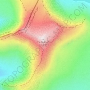
Nom : Carte topographique Oural, altitude, relief.
Altitude moyenne : 1 435 m
Altitude minimum : 1 101 m
Altitude maximum : 1 893 m