
Faire un don
Équipez-vous pour votre prochaine aventure :
En tant que Partenaire Amazon, ce site perçoit une commission sur les achats éligibles sans surcoût pour vous.
Carte topographique Carpates
Cliquez sur la carte pour afficher l’altitude.
Faire un don
Équipez-vous pour votre prochaine aventure :
En tant que Partenaire Amazon, ce site perçoit une commission sur les achats éligibles sans surcoût pour vous.
Carpates
Dans la partie roumaine des Carpates, les cols routiers les plus importants sont, de l'Ukraine à la frontière serbe : le col de Prislop, le col de Tihutsa, le défilé des gorges de Bicaz, le col de Predeal (altitude : 1 033 m), le défilé de la Tour rouge et le canyon des Portes de fer.
Faire un don
Équipez-vous pour votre prochaine aventure :
En tant que Partenaire Amazon, ce site perçoit une commission sur les achats éligibles sans surcoût pour vous.
À propos de cette carte
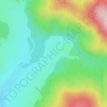
Nom : Carte topographique Carpates, altitude, relief.
Lieu : Carpates, Toplița, Harghita, 535705, Roumanie (47.00052 25.50167 47.00062 25.50177)
Altitude moyenne : 980 m
Altitude minimum : 867 m
Altitude maximum : 1 219 m
Faire un don
Équipez-vous pour votre prochaine aventure :
En tant que Partenaire Amazon, ce site perçoit une commission sur les achats éligibles sans surcoût pour vous.