
Carte topographique Pointe Dufour
Carte interactive
Cliquez sur la carte pour afficher l’altitude.
Pointe Dufour
La pointe Dufour (en allemand : Dufourspitze) est, à 4 634 mètres d'altitude, le plus haut sommet de Suisse et le plus haut sommet des Alpes en dehors du massif du Mont-Blanc. Elle est située dans le mont Rose, sur la commune de Zermatt, à quelques centaines de mètres de la frontière entre l'Italie et la Suisse. Elle a été nommée en souvenir du général et cartographe suisse Guillaume Henri Dufour.
À propos de cette carte
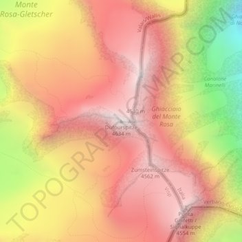
Nom : Carte topographique Pointe Dufour, altitude, relief.
Lieu : Pointe Dufour, Zermatt, Viège, Valais, 3920, Suisse (45.93686 7.86670 45.93696 7.86680)
Altitude moyenne : 4 033 m
Altitude minimum : 3 037 m
Altitude maximum : 4 619 m
Autres cartes topographiques
Cliquez sur une carte pour visualiser sa topographie, son altitude et son relief.