
Carte topographique Bajardo
Carte interactive
Cliquez sur la carte pour afficher l’altitude.
À propos de cette carte
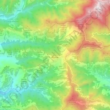
Nom : Carte topographique Bajardo, altitude, relief.
Lieu : Bajardo, Imperia, Ligurie, 18031, Italie (43.86526 7.68489 43.94367 7.77718)
Altitude moyenne : 710 m
Altitude minimum : 156 m
Altitude maximum : 1 610 m
Autres cartes topographiques
Cliquez sur une carte pour visualiser sa topographie, son altitude et son relief.
Torri Superiore
Italie > Ligurie > Imperia > Vintimille > Torri Inferiore > Torri Superiore
Altitude moyenne : 343 m
San Biagio della Cima
Italie > Ligurie > Imperia > San Biagio della Cima > San Biagio della Cima
Altitude moyenne : 170 m
I Palanchi
Italie > Ligurie > Imperia > Vintimille > Torri Inferiore > Torri Superiore
Altitude moyenne : 305 m
Borghetto San Nicolò
Italie > Ligurie > Imperia > Bordighera > Borghetto San Nicolò
Altitude moyenne : 168 m