Géolocaliser

Carte topographique Babati

Carte interactive

Cliquez sur la carte pour afficher l’altitude.

À propos de cette carte

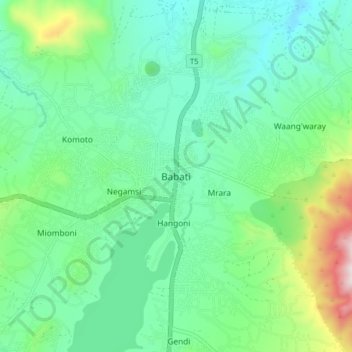
Nom : Carte topographique Babati, altitude, relief.

Lieu : Babati, Babati Municipal, Manyara Region, Northern Zone, Tanzania (-4.25006 35.70915 -4.17006 35.78915)

Altitude moyenne : 1 392 m

Altitude minimum : 1 206 m

Altitude maximum : 1 963 m

Babati town has developed from a mere village since Babati District was established in 1985. The new status boosted the town into rapid growth. The town is located at an altitude of 2,145 metres or 7,037 feet near the end of Tarangire National Park and the base of Lake Babati, nestling under Mount Kwaraha.

Wikipedia (CC-BY-SA 3.0)

Autres cartes topographiques

Cliquez sur une carte pour visualiser sa topographie, son altitude et son relief.

Simanjiro

Tanzania > Manyara Region

Simanjiro, Manyara Region, Northern Zone, Tanzania

Altitude moyenne : 1 111 m

Kwa Kuchinia

Tanzania > Manyara Region

Kwa Kuchinia, Babati, Manyara Region, Northern Zone, Tanzania

Altitude moyenne : 1 004 m