Géolocaliser

Carte topographique Sana'a

Carte interactive

Cliquez sur la carte pour afficher l’altitude.

À propos de cette carte
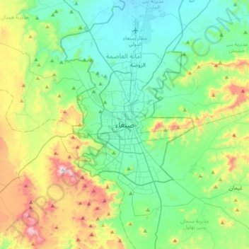
Nom : Carte topographique Sana'a, altitude, relief.

Lieu : Sana'a, At Tahrir District, Amanat Al Asimah, Yemen (15.19386 44.04588 15.51386 44.36588)

Altitude moyenne : 2 443 m

Altitude minimum : 2 172 m

Altitude maximum : 3 193 m

At an elevation of 2,300 metres (7,500 ft), Sanaa is one of the highest capital cities in the world and is next to the Sarawat Mountains of Jabal An-Nabi Shu'ayb and Jabal Tiyal, considered to be the highest mountains in the Arabian Peninsula and one of the highest in the region. Sanaa has a population of approximately 3,292,497 (2023), making it Yemen's largest city. As of 2020, the greater Sanaa urban area makes up about 10% of Yemen's total population.

Wikipedia (CC-BY-SA 3.0)

Autres cartes topographiques

Cliquez sur une carte pour visualiser sa topographie, son altitude et son relief.

Sana'a City

Yemen > Amanat Al Asimah > Sana'a City

Sana'a City, Amanat Al Asimah, Yemen

Altitude moyenne : 2 438 m