
Carte topographique Gallarate
Carte interactive
Cliquez sur la carte pour afficher l’altitude.
Gallarate
Fondée par les Gaulois et plus tard par les Romains conquise, Gallarate est mentionnée comme un important vicus ou village dans un document daté de l'époque de la conquête par les Romains de ce qui était alors appelé la Gaule cisalpine. Durant l'hégémonie franque, un château fut édifié sur les vestiges de fortifications romaines, situées près de la toujours existante Basilique Santa Maria. Le château n'existe plus désormais, mais sa localisation ancienne est perceptible dans la topographie de la cité et son souvenir perdure dans le nom de la rue intitulée Via Postcastello. Après l'anéantissement de Castelseprio par Ottone Visconti en 1287, Gallarate devient la capitale du Seprio, un vaste et important fief. Durant ces années, Gallarate connut une période de prospérité et de croissance économique qui perdura pendant tout le règne des membres de la Famille Visconti et des Sforza et se poursuivit jusqu'au début de la domination française, deux siècles plus tard (1498). Des documents conservés aux Archives Nationales décrivent Gallarate comme un important centre d'échange commercial entre les marchés italiens et étrangers, en particulier pour le coton, le lin et le draps. La vie de la cité est dominée par les classes nobles et marchandes. Cette période est aussi celle pendant laquelle Gallarate devient un centre d'activité industrielle, se développe et s'embellit. À la fin du XV siècle, la cité tombe sous domination étrangère, d'abord espagnole, puis française, de nouveau espagnole et enfin autrichienne, du XVI au XVIII siècle. C'est à Gallarate qu'eut lieu le ralliement d'une partie des troupes suisses à François Ier ou leur renoncement à prendre part aux combats, après la signature du Traité de Gallarate, épisode déterminant avant la bataille de Marignan. Au cœur de cette période d'instabilité politique, Gallarate devient un lieu d'affrontement de puissantes familles nobles italiennes en compétition comme les Bentivoglio, Pallavicino, Caraciolo, Altemps, Visconti, Castelbarco et Torriani, épisodes qu'évoque le roman Marco Visconti de Tommaseao Grassi. Elle continue cependant à avoir un rôle moteur dans l'économie du Haut Milanais et devient en 1786 le chef lieu d'une vaste province autrichienne. Avec l'avènement de Napoléon, se développe une bourgeoisie éclairée qui entend associer les nouvelles idées de liberté aux prémices de la révolution industrielle à venir. Après le moment de Restauration, sanctionné par le Congrès de Vienne, ces aspirations à la liberté s'amplifient et sont portées par des patriotes comme Luigi Borghi et Filippo Guenzati (incarcéré à la Forteresse du Spielberg) ou Giuseppe et Pompeo Castelli, propriétaires de la «farmacia del rinascimento», aujourd'hui Dahò, qui constitue le point de rencontre des partisans de l'indépendance et où la tradition veut que Gerolamo Rovetta ait conçu le roman Romanticismo.
À propos de cette carte
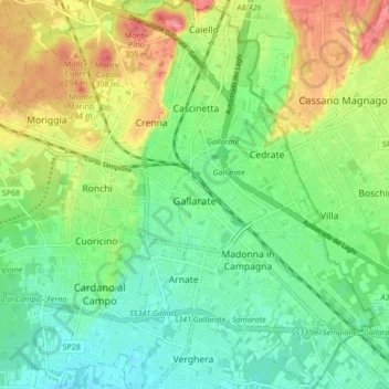
Nom : Carte topographique Gallarate, altitude, relief.
Lieu : Gallarate, Varèse, Lombardie, 21013, Italie (45.63119 8.75368 45.69043 8.83244)
Altitude moyenne : 254 m
Altitude minimum : 222 m
Altitude maximum : 309 m