
Faire un don
Équipez-vous pour votre prochaine aventure :
En tant que Partenaire Amazon, ce site perçoit une commission sur les achats éligibles sans surcoût pour vous.
Carte topographique Wildhorn
Cliquez sur la carte pour afficher l’altitude.
Faire un don
Équipez-vous pour votre prochaine aventure :
En tant que Partenaire Amazon, ce site perçoit une commission sur les achats éligibles sans surcoût pour vous.
Wildhorn
Le Wildhorn est un sommet des Alpes bernoises en Suisse. Culminant à 3 250 mètres d'altitude, il se trouve à la frontière entre les cantons de Berne et Valais.
Faire un don
Équipez-vous pour votre prochaine aventure :
En tant que Partenaire Amazon, ce site perçoit une commission sur les achats éligibles sans surcoût pour vous.
À propos de cette carte
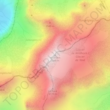
Nom : Carte topographique Wildhorn, altitude, relief.
Altitude moyenne : 2 760 m
Altitude minimum : 2 067 m
Altitude maximum : 3 225 m
Faire un don
Équipez-vous pour votre prochaine aventure :
En tant que Partenaire Amazon, ce site perçoit une commission sur les achats éligibles sans surcoût pour vous.
Autres cartes topographiques
Cliquez sur une carte pour visualiser sa topographie, son altitude et son relief.
Lac de Lauenen
Suisse > Berne > Arrondissement administratif du Haut-Simmental et Gessenay > Lauenen
Altitude moyenne : 1 590 m