
Carte topographique Albacete
Carte interactive
Cliquez sur la carte pour afficher l’altitude.
À propos de cette carte
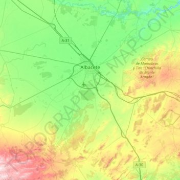
Nom : Carte topographique Albacete, altitude, relief.
Lieu : Albacete, Castille-La Manche, Espagne (38.67218 -2.18039 39.18626 -1.62279)
Altitude moyenne : 786 m
Altitude minimum : 560 m
Altitude maximum : 1 341 m
Autres cartes topographiques
Cliquez sur une carte pour visualiser sa topographie, son altitude et son relief.
Cubillejo de la Sierra
Espagne > Castille-La Manche > Molina de Aragón > Cubillejo de la Sierra
Altitude moyenne : 1 189 m
La Villa de Don Fadrique
Espagne > Castille-La Manche > Mancha Alta de Toledo > La Villa de Don Fadrique > La Villa de Don Fadrique
Altitude moyenne : 672 m
Lago del Jaral
Espagne > Castille-La Manche > El Casar > Mesones > Lago del Jaral
Altitude moyenne : 816 m
Tolède
Espagne > Castille-La Manche > Tolède > Tolède
La ville de Tolède est située dans le centre de l'Espagne, à 70 km au sud-ouest de Madrid. Elle est arrosée par le Tage. Son territoire municipal s'étend sur 232 km2 et son altitude moyenne est de 529 m.
Altitude moyenne : 590 m