Géolocaliser

Carte topographique Lac Serpent

Carte interactive

Cliquez sur la carte pour afficher l’altitude.

À propos de cette carte

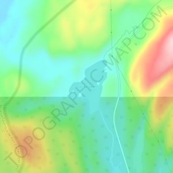
Nom : Carte topographique Lac Serpent, altitude, relief.

Lieu : Lac Serpent, Lac-Walker, Sept-Rivières, Côte-Nord, Québec, Canada (50.49728 -66.81849 50.50595 -66.80881)

Altitude moyenne : 476 m

Altitude minimum : 400 m

Altitude maximum : 622 m

Autres cartes topographiques

Cliquez sur une carte pour visualiser sa topographie, son altitude et son relief.

Lac Roger

Canada > Québec > Sept-Rivières > Lac-Walker

Lac Roger, Lac-Walker, Sept-Rivières, Côte-Nord, Québec, Canada

Altitude moyenne : 246 m

Lac Veillette

Canada > Québec > Sept-Rivières > Lac-Walker

Lac Veillette, Lac-Walker, Sept-Rivières, Côte-Nord, Québec, Canada

Altitude moyenne : 316 m

Lac-Walker

Canada > Québec > Sept-Rivières > Lac-Walker

Lac-Walker, Sept-Rivières, Côte-Nord, Québec, Canada

Altitude moyenne : 434 m

Lac Arthur

Canada > Québec > Sept-Rivières > Lac-Walker

Lac Arthur, Lac-Walker, Sept-Rivières, Côte-Nord, Québec, Canada

Altitude moyenne : 514 m

Lac Louisa

Canada > Québec > Sept-Rivières > Lac-Walker

Lac Louisa, Lac-Walker, Sept-Rivières, Côte-Nord, Québec, Canada

Altitude moyenne : 201 m

Lac Francis

Canada > Québec > Sept-Rivières > Lac-Walker

Lac Francis, Lac-Walker, Sept-Rivières, Côte-Nord, Québec, Canada

Altitude moyenne : 661 m

Lac Perle

Canada > Québec > Sept-Rivières > Lac-Walker

Lac Perle, Lac-Walker, Sept-Rivières, Côte-Nord, Québec, Canada

Altitude moyenne : 312 m

Lac Louisa

Canada > Québec > Sept-Rivières > Lac-Walker

Lac Louisa, Lac-Walker, Sept-Rivières, Côte-Nord, Québec, Canada

Altitude moyenne : 201 m