Géolocaliser

Carte topographique Iqaluit

Carte interactive

Cliquez sur la carte pour afficher l’altitude.

À propos de cette carte

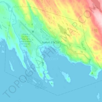
Nom : Carte topographique Iqaluit, altitude, relief.

Lieu : Iqaluit, ᐃᖃᓗᐃᑦ, Qikiqtaaluk Region, Nunavut, Canada (63.70852 -68.60121 63.77634 -68.42543)

Altitude moyenne : 51 m

Altitude minimum : 0 m

Altitude maximum : 252 m

Iqaluit has a tundra climate (Köppen: ET) typical of the Arctic region, although it is well outside the Arctic Circle. The city features long, cold winters and brief, cool summers. Average monthly temperatures are below freezing for eight months of the year. Iqaluit averages just over 400 mm (16 in) of precipitation annually, much wetter than many other localities in the Arctic Archipelago, with the summer being the wettest season. Temperatures of the winter months are comparable to other northern communities further west on the continent such as Yellowknife and to some extent even Fairbanks, Alaska, even though Iqaluit is a few degrees colder than the latter. Summer temperatures are, however, much colder due to its easterly maritime position affected by the waters of the cold Baffin Island Current. This means that the tree line is much further south in the eastern part of Canada, being as southbound, in spite of low elevation, as northern Labrador.

Wikipedia (CC-BY-SA 3.0)

Autres cartes topographiques

Cliquez sur une carte pour visualiser sa topographie, son altitude et son relief.

Iqaluit

Canada > Nunavut > ᐃᖃᓗᐃᑦ

Iqaluit, ᐃᖃᓗᐃᑦ, Qikiqtaaluk Region, Nunavut, Canada

Altitude moyenne : 50 m