
Carte topographique L'Aquila
Carte interactive
Cliquez sur la carte pour afficher l’altitude.
L'Aquila
Proche du plus haut sommet des Apennins, le Gran Sasso, L'Aquila est située à 721 m d'altitude, dans la vallée de l'Aterno-Pescara, coincée entre 4 montagnes supérieures à 2 000 m. Celles-ci bloquent l'arrivée des courants d'air maritimes doux et humides et font bénéficier la ville d'un climat sec et froid.
À propos de cette carte
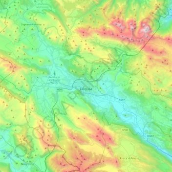
Nom : Carte topographique L'Aquila, altitude, relief.
Lieu : L'Aquila, Abruzzes, Italie (42.17658 13.17723 42.53155 13.65410)
Altitude moyenne : 1 192 m
Altitude minimum : 510 m
Altitude maximum : 2 844 m
Autres cartes topographiques
Cliquez sur une carte pour visualiser sa topographie, son altitude et son relief.
Apennins
Italie > Abruzzes > L'Aquila > L'Aquila
La chaîne entre deux mers forme, grosso modo, un arc entre le golfe de Gênes, sur la mer Méditerranée et Naples sur la mer Tyrrhénienne, le centre de l'arc s'approchant de la côte est, au niveau de Rimini (mer Adriatique). Les Apennins présentent cependant des bastions montagneux de faible altitude qui…
Altitude moyenne : 1 735 m