Carte topographique Province of Abancay
Carte interactive
Cliquez sur la carte pour afficher l’altitude.
À propos de cette carte
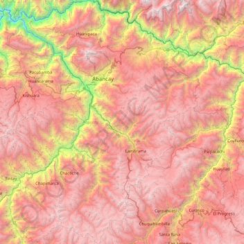
Nom : Carte topographique Province of Abancay, altitude, relief.
Lieu : Province of Abancay, Apurímac, 03041, Peru (-14.17039 -73.17190 -13.38303 -72.39879)
Altitude moyenne : 3 563 m
Altitude minimum : 1 027 m
Altitude maximum : 5 379 m
Autres cartes topographiques
Cliquez sur une carte pour visualiser sa topographie, son altitude et son relief.
Como Quishuar
Como Quishuar, Huayana, Province of Andahuaylas, Apurímac, Peru
Altitude moyenne : 3 811 m
Province of Cotabambas
Province of Cotabambas, Apurímac, Peru
Altitude moyenne : 3 876 m
Arica
Peru > Apurímac > Pacucha > Ranramocco
Arica, Ranramocco, Pacucha, Province of Andahuaylas, Apurímac, 03730, Peru
Altitude moyenne : 3 423 m
Soccoro
Peru > Apurímac > Huancarama > Soccoro
Soccoro, Huancarama, Province of Andahuaylas, Apurímac, Peru
Altitude moyenne : 3 053 m
Pampacancha
Peru > Apurímac > Progreso > Pampacancha
Pampacancha, Progreso, Province of Grau, Apurímac, Peru
Altitude moyenne : 3 817 m
Cochabamba
Peru > Apurímac > Cochabamba
Cochabamba, Abancay, Apurímac, 03041, Peru
Altitude moyenne : 2 736 m
Montevideo
Montevideo, Uranmarca, Province of Chincheros, Apurímac, Peru
Altitude moyenne : 3 249 m
Province of Cotabambas
Peru > Apurímac > Tambobamba
Province of Cotabambas, Tambobamba, Cotabambas, Apurímac, Peru
Altitude moyenne : 3 863 m
Cochabamba
Peru > Apurímac > Cochabamba
Cochabamba, Chincheros, Apurímac, Peru
Altitude moyenne : 3 578 m