
Carte topographique Oviède
Carte interactive
Cliquez sur la carte pour afficher l’altitude.
Oviède
La ville se trouve au centre des Asturies, entre 80 et 708 mètres d'altitude. Elle est bordée au nord par les communes de Las Regueras et Llanera ; au sud, par Santo Adriano, Ribera de Arriba et Mieres ; à l'ouest, par Grado ; à l'est, par Siero et Langreo.
À propos de cette carte
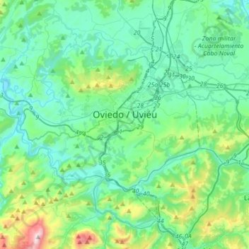
Nom : Carte topographique Oviède, altitude, relief.
Lieu : Oviède, Asturies, Espagne (43.27914 -6.01694 43.42732 -5.74239)
Altitude moyenne : 284 m
Altitude minimum : 59 m
Altitude maximum : 1 282 m
Autres cartes topographiques
Cliquez sur une carte pour visualiser sa topographie, son altitude et son relief.
Bulnes de Arriba (El Castillo)
Espagne > Asturies > Cabrales > Bulnes de Arriba (El Castillo)
Altitude moyenne : 1 138 m
Langreo / Llangréu
Espagne > Asturies > Llangréu/Langreo > Langreo / Llangréu
Altitude moyenne : 383 m