Géolocaliser

Carte topographique Sincelejo

Carte interactive

Cliquez sur la carte pour afficher l’altitude.

À propos de cette carte

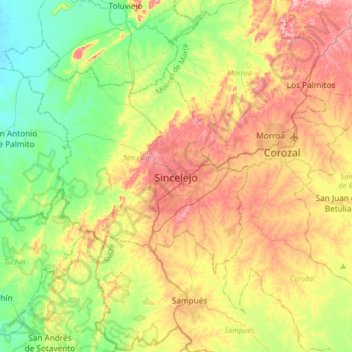
Nom : Carte topographique Sincelejo, altitude, relief.

Lieu : Sincelejo, Montes de María, Sucre, RAP Caribe, 700020, Colombia (9.13734 -75.55266 9.45734 -75.23266)

Altitude moyenne : 121 m

Altitude minimum : 15 m

Altitude maximum : 274 m

The geography of Sincelejo is characterized by a hilly landscape which extends from the mountains to the borders of the plateau in the north and south. The small mountain foothills in the municipality span from the marine fluvial plain in the west to the border shared with the town of Palmito. Erosion is common in the rugged topography of the rolling hills, which are moderately to strongly broken, with slopes between 7 and 50% and altitudes ranging from 50 to 260 meters.

Wikipedia (CC-BY-SA 3.0)