Géolocaliser

Carte topographique Potsdam

Carte interactive

Cliquez sur la carte pour afficher l’altitude.

À propos de cette carte

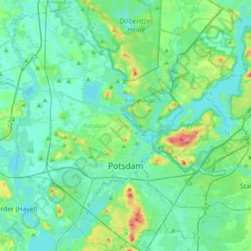
Nom : Carte topographique Potsdam, altitude, relief.

Lieu : Potsdam, Brandenburg, Germany (52.34204 12.88678 52.51469 13.16820)

Altitude moyenne : 40 m

Altitude minimum : 25 m

Altitude maximum : 103 m

The traditional towns in the governorate were small, however, in the course of the industrial labour migration some reached the rank of urban districts. The principal towns were Brandenburg upon Havel, Köpenick, Potsdam, Prenzlau, Spandau and Ruppin. Until 1875 Berlin also was a town within the governorate. After its disentanglement a number of its suburbs outside Berlin's municipal borders grew to towns, many forming urban Bezirke within the governorate of Potsdam such as Charlottenburg, Lichtenberg, Rixdorf (after 1912 Neukölln), and Schöneberg (all of which, as well as Köpenick and Spandau, incorporated into Greater Berlin in 1920). The urban Bezirke were (years indicating the elevation to rank of urban Bezirkor affiliation with Potsdam governorate, respectively):

Wikipedia (CC-BY-SA 3.0)

Autres cartes topographiques

Cliquez sur une carte pour visualiser sa topographie, son altitude et son relief.

Museumsdorf Glashütte

Germany > Brandenburg > Teltow-Fläming > Baruth/Mark

Museumsdorf Glashütte, Klasdorf, Baruth/Mark, Teltow-Fläming, Brandenburg, Germany

Altitude moyenne : 57 m

Uckermark

Germany > Brandenburg

Uckermark, Brandenburg, Germany

Altitude moyenne : 53 m

Cottbus - Chóśebuz

Germany > Brandenburg > Cottbus - Chóśebuz

Cottbus - Chóśebuz, Brandenburg, Germany

Altitude moyenne : 69 m

Schwielochsee

Germany > Brandenburg > Schwielochsee

Schwielochsee, Lieberose/Oberspreewald, Dahme-Spreewald, Brandenburg, Germany

Altitude moyenne : 56 m

Kremmen

Germany > Brandenburg > Kremmen

Kremmen, Oberhavel, Brandenburg, 16766, Germany

Altitude moyenne : 43 m

D 25

Germany > Brandenburg > Kolkwitz

D 25, Kolkwitz, Spree-Neiße, Brandenburg, 03099, Germany

Altitude moyenne : 68 m

D 45

Germany > Brandenburg > Neuhausen/Spree

D 45, Neuhausen/Spree, Spree-Neiße, Brandenburg, Germany

Altitude moyenne : 99 m