
Carte topographique Cazorla
Carte interactive
Cliquez sur la carte pour afficher l’altitude.
À propos de cette carte
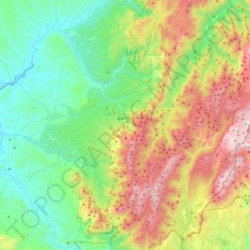
Nom : Carte topographique Cazorla, altitude, relief.
Lieu : Cazorla, Jaén, Andalousie, Espagne (37.79111 -3.19173 38.01447 -2.77362)
Altitude moyenne : 929 m
Altitude minimum : 361 m
Altitude maximum : 2 066 m
Autres cartes topographiques
Cliquez sur une carte pour visualiser sa topographie, son altitude et son relief.
Paraje Natural del Desierto de Tabernas
Le climat du désert de Tabernas, en deçà de l'altitude de 800-900 mètres, est un climat désertique froid (BWk dans la classification de Köppen) avec un hiver frais où la moyenne du mois le plus froid s'établit entre 0 °C et 10 °C et un maximum de sécheresse en été.
Altitude moyenne : 612 m
Sierra Nevada
Espagne > Andalousie > Comarca de la Alpujarra Granadina > Lanjarón
Altitude moyenne : 2 223 m