
Carte topographique Santa Ana
Carte interactive
Cliquez sur la carte pour afficher l’altitude.
À propos de cette carte
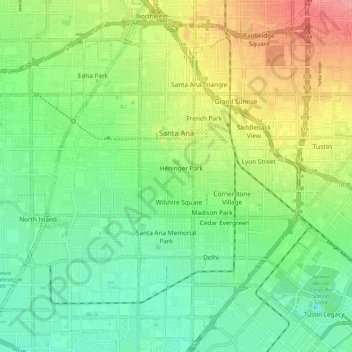
Nom : Carte topographique Santa Ana, altitude, relief.
Altitude moyenne : 30 m
Altitude minimum : -1 m
Altitude maximum : 80 m
Autres cartes topographiques
Cliquez sur une carte pour visualiser sa topographie, son altitude et son relief.
San Joaquin Hills
États-Unis d'Amérique > Californie > Orange County > Newport Beach
Altitude moyenne : 153 m
Thurin
États-Unis d'Amérique > Californie > Orange County > Costa Mesa > Thurin
Altitude moyenne : 24 m
Newport Beach
États-Unis d'Amérique > Californie > Orange County > Newport Beach > Newport Beach
Altitude moyenne : 9 m