
Carte topographique Potosí
Carte interactive
Cliquez sur la carte pour afficher l’altitude.
Potosí
Potosí est une ville de Bolivie et la capitale du département de Potosí. Son nom vient du quechua Potojsi qui signifie « tonnerre ». Elle se trouve à une altitude de 4 070 m et comptait environ 164 480 habitants en 2007. C'est une des villes les plus hautes du monde, construite au pied du Cerro Rico (« Montagne riche »), une montagne de minerai d'argent qui domine la ville de ses 4 782 m.
À propos de cette carte
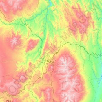
Nom : Carte topographique Potosí, altitude, relief.
Lieu : Potosí, Provincia Tomás Frías, Potosí, Bolivie (-19.80525 -65.96351 -19.26264 -65.54740)
Altitude moyenne : 3 961 m
Altitude minimum : 3 106 m
Altitude maximum : 5 014 m
Autres cartes topographiques
Cliquez sur une carte pour visualiser sa topographie, son altitude et son relief.
Turqui
Bolivie > Potosí > Provincia Tomás Frías > Municipio Yocalla > Turqui
Altitude moyenne : 3 801 m