
Carte topographique Potenza
Carte interactive
Cliquez sur la carte pour afficher l’altitude.
Potenza
Les falaises, entre environ 600 m et 1 500 m d'altitude, sont utilisées pour l'alpinisme entre avril et octobre[5].
À propos de cette carte
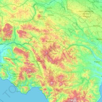
Nom : Carte topographique Potenza, altitude, relief.
Lieu : Potenza, Basilicate, Italie (39.89581 15.33497 41.14090 16.39957)
Altitude moyenne : 521 m
Altitude minimum : 0 m
Altitude maximum : 2 186 m
Autres cartes topographiques
Cliquez sur une carte pour visualiser sa topographie, son altitude et son relief.
Potenza
Italie > Basilicate > Potenza > Potenza
La ville est située dans la haute vallée du Basento et dominée par les Apennins dont notamment les monts Li Foj, sur une zone sismique. La ville ancienne culmine à 819 m d'altitude et les quartiers modernes sont étagés jusqu'au cours de la rivière.
Altitude moyenne : 824 m