
Faire un don
Équipez-vous pour votre prochaine aventure :
En tant que Partenaire Amazon, ce site perçoit une commission sur les achats éligibles sans surcoût pour vous.
Carte topographique Garmisch-Partenkirchen
Cliquez sur la carte pour afficher l’altitude.
Faire un don
Équipez-vous pour votre prochaine aventure :
En tant que Partenaire Amazon, ce site perçoit une commission sur les achats éligibles sans surcoût pour vous.
À propos de cette carte
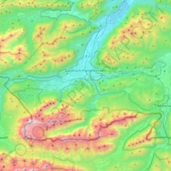
Nom : Carte topographique Garmisch-Partenkirchen, altitude, relief.
Altitude moyenne : 1 326 m
Altitude minimum : 633 m
Altitude maximum : 2 945 m
Faire un don
Équipez-vous pour votre prochaine aventure :
En tant que Partenaire Amazon, ce site perçoit une commission sur les achats éligibles sans surcoût pour vous.
Autres cartes topographiques
Cliquez sur une carte pour visualiser sa topographie, son altitude et son relief.
Zugspitze
Allemagne > Bavière > Landkreis Garmisch-Partenkirchen > Grainau
La Zugspitze est un sommet situé dans la chaîne des Alpes, dans le massif du Wetterstein, dans les Alpes bavaroises. C'est le point culminant de l'Allemagne, avec 2 962 mètres d'altitude. La Zugspitze se situe sur la frontière autrichienne, mais le point culminant est en Allemagne. Elle fait partie du…
Altitude moyenne : 2 300 m