
Faire un don
Équipez-vous pour votre prochaine aventure :
En tant que Partenaire Amazon, ce site perçoit une commission sur les achats éligibles sans surcoût pour vous.
Carte topographique Boulder
Cliquez sur la carte pour afficher l’altitude.
Faire un don
Équipez-vous pour votre prochaine aventure :
En tant que Partenaire Amazon, ce site perçoit une commission sur les achats éligibles sans surcoût pour vous.
Boulder
Boulder, implantée à 1 665 mètres d'altitude, est située dans la vallée de Boulder, où les montagnes Rocheuses rencontrent les Grandes Plaines. Boulder est célèbre pour ses Flatirons, une chaîne de montagne qui surplombe la ville. Ces formations se présentent sous la forme de grandes facettes rocheuses inclinées vers la plaine.
Faire un don
Équipez-vous pour votre prochaine aventure :
En tant que Partenaire Amazon, ce site perçoit une commission sur les achats éligibles sans surcoût pour vous.
À propos de cette carte
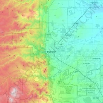
Nom : Carte topographique Boulder, altitude, relief.
Altitude moyenne : 1 977 m
Altitude minimum : 1 495 m
Altitude maximum : 3 187 m
Faire un don
Équipez-vous pour votre prochaine aventure :
En tant que Partenaire Amazon, ce site perçoit une commission sur les achats éligibles sans surcoût pour vous.