Géolocaliser

Carte topographique Zaragoza

Carte interactive

Cliquez sur la carte pour afficher l’altitude.

À propos de cette carte
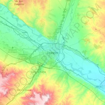
Nom : Carte topographique Zaragoza, altitude, relief.

Lieu : Zaragoza, Aragon, 50001, Spain (41.49213 -1.04094 41.81213 -0.72094)

Altitude moyenne : 310 m

Altitude minimum : 169 m

Altitude maximum : 646 m

On 1 January 2019 the population of the municipality of Zaragoza was 706,904, (the fifth most populated in Spain) on a land area of 973.78 square kilometres (375.98 square miles). The population of the metropolitan area was estimated in 2006 at 783,763 inhabitants. The municipality is home to more than 50 percent of the Aragonese population. The city lies at an elevation of about 208 metres (682 feet) above sea level.