Carte topographique Sept-Îles
Carte interactive
Cliquez sur la carte pour afficher l’altitude.
À propos de cette carte
![Carte topographique Sept-Îles, altitude, relief](/pub/maps/relation/lnb3/pgfttj/thumbnail.jpg)
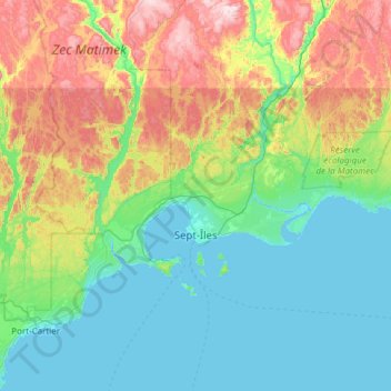
Nom : Carte topographique Sept-Îles, altitude, relief.
Lieu : Sept-Îles, Sept-Rivières, Côte-Nord, Québec, Canada (50.07828 -66.72530 50.49399 -65.51313)
Altitude moyenne : 189 m
Altitude minimum : -4 m
Altitude maximum : 802 m
Autres cartes topographiques
Cliquez sur une carte pour visualiser sa topographie, son altitude et son relief.
![Carte topographique Lac Brunelle, altitude, relief](/pub/maps/way/dkdn/dtdzx4s/icon.jpg)
Lac Brunelle
Canada > Québec > Sept-Rivières > Lac-Walker
Lac Brunelle, Lac-Walker, Sept-Rivières, Côte-Nord, Québec, Canada
Altitude moyenne : 150 m
![Carte topographique Lac Pentecôte, altitude, relief](/pub/maps/relation/l218/z96p5k/icon.jpg)
Lac Pentecôte
Canada > Québec > Sept-Rivières > Lac-Walker
Lac Pentecôte, Lac-Walker, Sept-Rivières, Côte-Nord, Québec, Canada
Altitude moyenne : 233 m
![Carte topographique Lac Serpent, altitude, relief](/pub/maps/relation/k5t6/28rdtp/icon.jpg)
Lac Serpent
Canada > Québec > Sept-Rivières > Lac-Walker
Lac Serpent, Lac-Walker, Sept-Rivières, Côte-Nord, Québec, Canada
Altitude moyenne : 476 m
![Carte topographique Lac Dufresne, altitude, relief](/pub/maps/relation/8j9m/d5cc3q/icon.jpg)
Lac Dufresne
Canada > Québec > Sept-Rivières > Rivière-Nipissis
Lac Dufresne, Rivière-Nipissis, Sept-Rivières, Côte-Nord, Québec, Canada
Altitude moyenne : 675 m
![Carte topographique Petite rivière au Bouleau, altitude, relief](/pub/maps/relation/3k18/26x3tf/icon.jpg)
Petite rivière au Bouleau
Canada > Québec > Sept-Rivières > Rivière-Nipissis
Petite rivière au Bouleau, Rivière-Nipissis, Sept-Rivières, Côte-Nord, Québec, Canada
Altitude moyenne : 481 m
![Carte topographique Îles du Crique à Richmond, altitude, relief](/pub/maps/node/j657/6xh9m4f3/icon.jpg)
Îles du Crique à Richmond
Canada > Québec > Sept-Rivières
Îles du Crique à Richmond, Sept-Rivières, Côte-Nord, Québec, Canada
Altitude moyenne : 120 m
![Carte topographique Lac Roger, altitude, relief](/pub/maps/relation/8z1h/tqbltj/icon.jpg)
Lac Roger
Canada > Québec > Sept-Rivières > Lac-Walker
Lac Roger, Lac-Walker, Sept-Rivières, Côte-Nord, Québec, Canada
Altitude moyenne : 246 m
![Carte topographique Lac Veillette, altitude, relief](/pub/maps/way/d3tp/78m62gt/icon.jpg)
Lac Veillette
Canada > Québec > Sept-Rivières > Lac-Walker
Lac Veillette, Lac-Walker, Sept-Rivières, Côte-Nord, Québec, Canada
Altitude moyenne : 316 m
![Carte topographique Rivière Pentecôte, altitude, relief](/pub/maps/way/6z4/3gt3qrs8/icon.jpg)
Rivière Pentecôte
Canada > Québec > Sept-Rivières > Port-Cartier
Rivière Pentecôte, Port-Cartier, Sept-Rivières, Côte-Nord, Québec, Canada
Altitude moyenne : 120 m
![Carte topographique Lac-Walker, altitude, relief](/pub/maps/relation/mstp/rmp45k/icon.jpg)
Lac-Walker
Canada > Québec > Sept-Rivières > Lac-Walker
Lac-Walker, Sept-Rivières, Côte-Nord, Québec, Canada
Altitude moyenne : 434 m
![Carte topographique Lac Donaldson, altitude, relief](/pub/maps/way/5257/lp74n1h/icon.jpg)
Lac Donaldson
Canada > Québec > Sept-Rivières > Port-Cartier
Lac Donaldson, Port-Cartier, Sept-Rivières, Côte-Nord, Québec, Canada
Altitude moyenne : 296 m
![Carte topographique Lac-Labrie, altitude, relief](/pub/maps/node/wps8/hk17d65k/icon.jpg)
Lac-Labrie
Canada > Québec > Sept-Rivières > Sept-Îles
Lac-Labrie, Sept-Îles, Sept-Rivières, Côte-Nord, Québec, Canada
Altitude moyenne : 101 m
![Carte topographique Port-Cartier, altitude, relief](/pub/maps/relation/ftzs/w4rxb3/icon.jpg)
Port-Cartier
Canada > Québec > Sept-Rivières
Port-Cartier, Sept-Rivières, Côte-Nord, Québec, Canada
Altitude moyenne : 77 m
![Carte topographique Lac Arthur, altitude, relief](/pub/maps/relation/793l/gwh9gp/icon.jpg)
Lac Arthur
Canada > Québec > Sept-Rivières > Lac-Walker
Lac Arthur, Lac-Walker, Sept-Rivières, Côte-Nord, Québec, Canada
Altitude moyenne : 514 m
![Carte topographique Lac Louisa, altitude, relief](/pub/maps/way/vfcz/xls6fz4/icon.jpg)
Lac Louisa
Canada > Québec > Sept-Rivières > Lac-Walker
Lac Louisa, Lac-Walker, Sept-Rivières, Côte-Nord, Québec, Canada
Altitude moyenne : 201 m
![Carte topographique Lac Francis, altitude, relief](/pub/maps/way/lxz4/7sptt7t6/icon.jpg)
Lac Francis
Canada > Québec > Sept-Rivières > Lac-Walker
Lac Francis, Lac-Walker, Sept-Rivières, Côte-Nord, Québec, Canada
Altitude moyenne : 661 m
![Carte topographique Lac Caro, altitude, relief](/pub/maps/relation/lwgt/z74mtj/icon.jpg)
Lac Caro
Canada > Québec > Sept-Rivières > Port-Cartier
Lac Caro, Port-Cartier, Sept-Rivières, Côte-Nord, Québec, Canada
Altitude moyenne : 276 m
![Carte topographique Rivière aux Rats Musqués, altitude, relief](/pub/maps/way/85dn/32bsqtj/icon.jpg)
Rivière aux Rats Musqués
Canada > Québec > Sept-Rivières > Sept-Îles
Rivière aux Rats Musqués, Sept-Îles, Sept-Rivières, Côte-Nord, Québec, Canada
Altitude moyenne : 173 m
![Carte topographique Lac Perle, altitude, relief](/pub/maps/way/4dgt/w3bqh5k/icon.jpg)
Lac Perle
Canada > Québec > Sept-Rivières > Lac-Walker
Lac Perle, Lac-Walker, Sept-Rivières, Côte-Nord, Québec, Canada
Altitude moyenne : 312 m
![Carte topographique Lac des Rapides, altitude, relief](/pub/maps/relation/sxb3/v95q51/icon.jpg)
Lac des Rapides
Canada > Québec > Sept-Rivières > Sept-Îles
Lac des Rapides, Sept-Îles, Sept-Rivières, Côte-Nord, Québec, Canada
Altitude moyenne : 199 m
![Carte topographique Lac Pioui, altitude, relief](/pub/maps/way/m2z4/62z37kl/icon.jpg)
Lac Pioui
Canada > Québec > Sept-Rivières > Sept-Îles
Lac Pioui, Sept-Îles, Sept-Rivières, Côte-Nord, Québec, Canada
Altitude moyenne : 128 m
![Carte topographique Lac Louisa, altitude, relief](/pub/maps/way/t1dn/stnnkrr/icon.jpg)
Lac Louisa
Canada > Québec > Sept-Rivières > Lac-Walker
Lac Louisa, Lac-Walker, Sept-Rivières, Côte-Nord, Québec, Canada
Altitude moyenne : 201 m